You are here: Home > Network List > AV - Alaska Volcano Observatory Stations List
> Station SPCL Chakachamna Lake, Mount Spurr, Alaska > Earthquake Result Viewer
SPCL Chakachamna Lake, Mount Spurr, Alaska - Earthquake Result Viewer
| Earthquake location: |
Near Coast Of Nicaragua |
| Earthquake latitude/longitude: |
11.5/-87.0 |
| Earthquake time(UTC): |
2022/04/21 (111) 07:42:51 GMT |
| Earthquake Depth: |
10 km |
| Earthquake Magnitude: |
6.8 Mi |
| Earthquake Catalog/Contributor: |
NEIC PDE/at |
|
| Network: |
AV Alaska Volcano Observatory |
| Station: |
SPCL Chakachamna Lake, Mount Spurr, Alaska |
| Lat/Lon: |
61.20 N/152.34 W |
| Elevation: |
1274 m |
|
| Distance: |
68.2 deg |
| Az: |
331.703 deg |
| Baz: |
106.382 deg |
| Ray Param: |
0.05646222 |
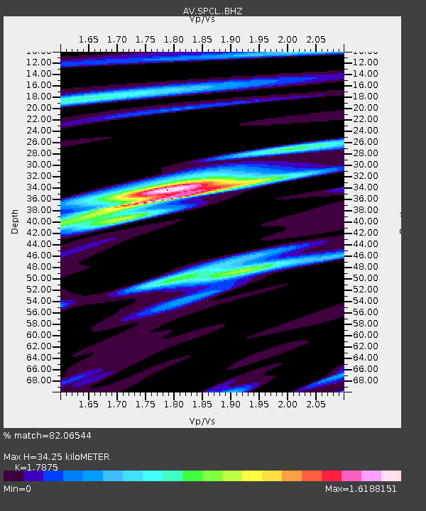
| Estimated Moho Depth: |
34.25 km |
| Estimated Crust Vp/Vs: |
1.79 |
| Assumed Crust Vp: |
6.566 km/s |
| Estimated Crust Vs: |
3.673 km/s |
| Estimated Crust Poisson's Ratio: |
0.27 |
|
| Radial Match: |
82.06544 % |
| Radial Bump: |
384 |
| Transverse Match: |
70.228325 % |
| Transverse Bump: |
400 |
| SOD ConfigId: |
27527651 |
| Insert Time: |
2022-05-05 07:51:14.021 +0000 |
| GWidth: |
2.5 |
| Max Bumps: |
400 |
| Tol: |
0.001 |
|

Signal To Noise
| Channel | StoN | STA | LTA |
| AV:SPCL: :BHZ:20220421T07:53:20.299988Z | 1.8301231 | 1.3003122E-6 | 7.105054E-7 |
| AV:SPCL: :BHN:20220421T07:53:20.299988Z | 2.0929568 | 5.222063E-7 | 2.4950648E-7 |
| AV:SPCL: :BHE:20220421T07:53:20.299988Z | 2.346733 | 9.396004E-7 | 4.0038654E-7 |
| Arrivals |
| Ps | 4.3 SECOND |
| PpPs | 14 SECOND |
| PsPs/PpSs | 18 SECOND |


