You are here: Home > Network List > AZ - ANZA Regional Network Stations List
> Station SIO5 Mt. Soledad, La Jolla, CA > Earthquake Result Viewer
SIO5 Mt. Soledad, La Jolla, CA - Earthquake Result Viewer
| Earthquake location: |
Near Coast Of Nicaragua |
| Earthquake latitude/longitude: |
11.5/-87.0 |
| Earthquake time(UTC): |
2022/04/21 (111) 07:42:51 GMT |
| Earthquake Depth: |
10 km |
| Earthquake Magnitude: |
6.8 Mi |
| Earthquake Catalog/Contributor: |
NEIC PDE/at |
|
| Network: |
AZ ANZA Regional Network |
| Station: |
SIO5 Mt. Soledad, La Jolla, CA |
| Lat/Lon: |
32.84 N/117.25 W |
| Elevation: |
217 m |
|
| Distance: |
34.9 deg |
| Az: |
312.233 deg |
| Baz: |
120.447 deg |
| Ray Param: |
0.07748818 |
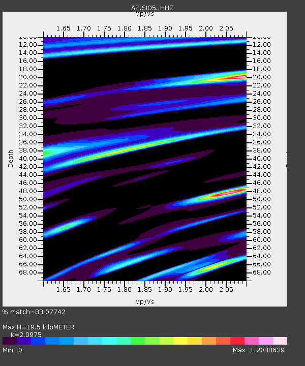
| Estimated Moho Depth: |
19.5 km |
| Estimated Crust Vp/Vs: |
2.10 |
| Assumed Crust Vp: |
6.264 km/s |
| Estimated Crust Vs: |
2.986 km/s |
| Estimated Crust Poisson's Ratio: |
0.35 |
|
| Radial Match: |
83.07742 % |
| Radial Bump: |
364 |
| Transverse Match: |
66.98901 % |
| Transverse Bump: |
400 |
| SOD ConfigId: |
27527651 |
| Insert Time: |
2022-05-05 07:52:04.304 +0000 |
| GWidth: |
2.5 |
| Max Bumps: |
400 |
| Tol: |
0.001 |
|

Signal To Noise
| Channel | StoN | STA | LTA |
| AZ:SIO5: :HHZ:20220421T07:49:12.213013Z | 12.334413 | 3.9469114E-6 | 3.1999184E-7 |
| AZ:SIO5: :HHN:20220421T07:49:12.213013Z | 4.029943 | 2.702597E-6 | 6.7062905E-7 |
| AZ:SIO5: :HHE:20220421T07:49:12.213013Z | 4.4184394 | 3.124869E-6 | 7.072336E-7 |
| Arrivals |
| Ps | 3.6 SECOND |
| PpPs | 9.1 SECOND |
| PsPs/PpSs | 13 SECOND |


