You are here: Home > Network List > US - United States National Seismic Network Stations List
> Station LAO LASA Array, Montana, USA > Earthquake Result Viewer
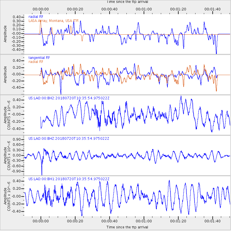
LAO LASA Array, Montana, USA - Earthquake Result Viewer
*The percent match for this event was below the threshold and hence no stack was calculated.
| Earthquake location: |
Santiago Del Estero Prov., Arg. |
| Earthquake latitude/longitude: |
-28.1/-63.3 |
| Earthquake time(UTC): |
2018/07/20 (201) 10:24:57 GMT |
| Earthquake Depth: |
588 km |
| Earthquake Magnitude: |
5.6 Mww |
| Earthquake Catalog/Contributor: |
NEIC PDE/us |
|
| Network: |
US United States National Seismic Network |
| Station: |
LAO LASA Array, Montana, USA |
| Lat/Lon: |
46.69 N/106.22 W |
| Elevation: |
902 m |
|
| Distance: |
83.9 deg |
| Az: |
331.845 deg |
| Baz: |
142.72 deg |
| Ray Param: |
$rayparam |
*The percent match for this event was below the threshold and hence was not used in the summary stack. |
|
| Radial Match: |
46.438152 % |
| Radial Bump: |
400 |
| Transverse Match: |
67.42117 % |
| Transverse Bump: |
400 |
| SOD ConfigId: |
2778632 |
| Insert Time: |
2018-08-03 10:32:27.853 +0000 |
| GWidth: |
2.5 |
| Max Bumps: |
400 |
| Tol: |
0.001 |
|
Signal To Noise
| Channel | StoN | STA | LTA |
| US:LAO:00:BHZ:20180720T10:35:54.975022Z | 2.5572228 | 3.1133615E-7 | 1.2174776E-7 |
| US:LAO:00:BH1:20180720T10:35:54.975022Z | 0.88356817 | 1.2157392E-7 | 1.3759427E-7 |
| US:LAO:00:BH2:20180720T10:35:54.975022Z | 0.87498635 | 1.7029835E-7 | 1.9462972E-7 |
| Arrivals |
| Ps | |
| PpPs | |
| PsPs/PpSs | |


