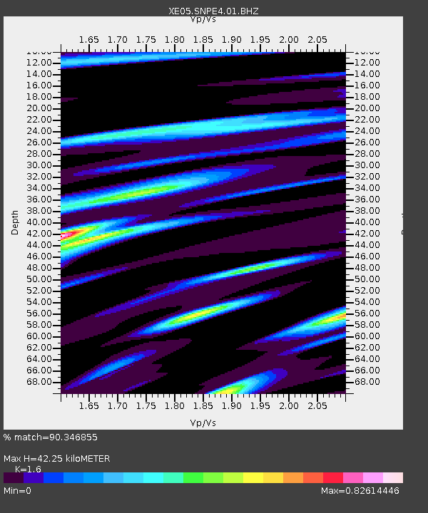
SNPE4 SNPE4 - Earthquake Result Viewer

Earthquake location: Near Coast Of Peru
Earthquake latitude/longitude: -13.5/-76.7
Earthquake time(UTC): 2006/10/20 (293) 10:48:56 GMT
Earthquake Depth: 23 km
Earthquake Magnitude: 5.9 MB, 6.6 MS, 6.7 MW, 6.6 MW
Earthquake Catalog/Contributor: WHDF/NEIC
Network: XE Sierra Nevada EarthScope Project- EarthScope Flex Array
Station: SNPE4 SNPE4
Lat/Lon: 39.24 N/121.35 W
Elevation: 88 m
Distance: 66.9 deg
Az: 323.602 deg
Baz: 131.982 deg
Ray Param: 0.05725276
Estimated Moho Depth: 42.25 km
Estimated Crust Vp/Vs: 1.60
Assumed Crust Vp: 6.597 km/s
Estimated Crust Vs: 4.123 km/s
Estimated Crust Poisson's Ratio: 0.18
Radial Match: 90.346855 %
Radial Bump: 374
Transverse Match: 79.80661 %
Transverse Bump: 400
SOD ConfigId: 268666
Insert Time: 2010-03-09 19:00:22.507 +0000
GWidth: 2.5
Max Bumps: 400
Tol: 0.001

Signal To Noise

ChannelStoNSTALTA
XE:SNPE4:01:BHZ:20061020T10:59:15.465017Z2.7339447.411217E-72.7108152E-7
XE:SNPE4:01:BHN:20061020T10:59:15.465017Z0.76354571.8510055E-72.4242235E-7
XE:SNPE4:01:BHE:20061020T10:59:15.465017Z4.32274683.8224454E-78.8426305E-8
Arrivals
Ps4.0 SECOND
PpPs16 SECOND
PsPs/PpSs20 SECOND