You are here: Home > Network List > XE05 - Sierra Nevada EarthScope Project- EarthScope Flex Array Stations List
> Station SNPE4 SNPE4 > Earthquake Result Viewer
SNPE4 SNPE4 - Earthquake Result Viewer
| Earthquake location: |
Santiago Del Estero Prov., Arg. |
| Earthquake latitude/longitude: |
-26.0/-63.2 |
| Earthquake time(UTC): |
2006/11/13 (317) 01:26:34 GMT |
| Earthquake Depth: |
552 km |
| Earthquake Magnitude: |
6.3 MB, 6.8 MW, 6.8 MW |
| Earthquake Catalog/Contributor: |
WHDF/NEIC |
|
| Network: |
XE Sierra Nevada EarthScope Project- EarthScope Flex Array |
| Station: |
SNPE4 SNPE4 |
| Lat/Lon: |
39.24 N/121.35 W |
| Elevation: |
88 m |
|
| Distance: |
84.6 deg |
| Az: |
318.514 deg |
| Baz: |
129.882 deg |
| Ray Param: |
0.043767326 |
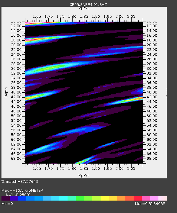
| Estimated Moho Depth: |
10.5 km |
| Estimated Crust Vp/Vs: |
1.61 |
| Assumed Crust Vp: |
6.597 km/s |
| Estimated Crust Vs: |
4.091 km/s |
| Estimated Crust Poisson's Ratio: |
0.19 |
|
| Radial Match: |
87.57643 % |
| Radial Bump: |
400 |
| Transverse Match: |
73.752914 % |
| Transverse Bump: |
400 |
| SOD ConfigId: |
268666 |
| Insert Time: |
2010-03-09 19:00:24.841 +0000 |
| GWidth: |
2.5 |
| Max Bumps: |
400 |
| Tol: |
0.001 |
|

Signal To Noise
| Channel | StoN | STA | LTA |
| XE:SNPE4:01:BHZ:20061113T01:37:38.489001Z | 1.5684246 | 5.839208E-7 | 3.7229762E-7 |
| XE:SNPE4:01:BHN:20061113T01:37:38.489001Z | 0.4456073 | 1.05540146E-7 | 2.3684564E-7 |
| XE:SNPE4:01:BHE:20061113T01:37:38.489001Z | 1.5175787 | 3.901478E-7 | 2.570857E-7 |
| Arrivals |
| Ps | 1.0 SECOND |
| PpPs | 4.0 SECOND |
| PsPs/PpSs | 5.0 SECOND |


