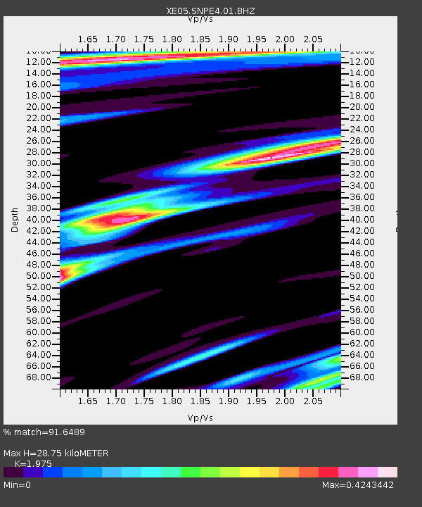
SNPE4 SNPE4 - Earthquake Result Viewer

Earthquake location: East Of Kuril Islands
Earthquake latitude/longitude: 46.2/154.4
Earthquake time(UTC): 2006/12/07 (341) 19:10:21 GMT
Earthquake Depth: 16 km
Earthquake Magnitude: 6.3 MB, 6.1 MS, 6.3 MW, 6.3 MW
Earthquake Catalog/Contributor: WHDF/NEIC
Network: XE Sierra Nevada EarthScope Project- EarthScope Flex Array
Station: SNPE4 SNPE4
Lat/Lon: 39.24 N/121.35 W
Elevation: 88 m
Distance: 59.5 deg
Az: 63.685 deg
Baz: 306.646 deg
Ray Param: 0.062100597
Estimated Moho Depth: 28.75 km
Estimated Crust Vp/Vs: 1.98
Assumed Crust Vp: 6.597 km/s
Estimated Crust Vs: 3.341 km/s
Estimated Crust Poisson's Ratio: 0.33
Radial Match: 91.6489 %
Radial Bump: 301
Transverse Match: 67.065094 %
Transverse Bump: 400
SOD ConfigId: 268666
Insert Time: 2010-03-09 19:00:27.849 +0000
GWidth: 2.5
Max Bumps: 400
Tol: 0.001

Signal To Noise

ChannelStoNSTALTA
XE:SNPE4:01:BHZ:20061207T19:19:53.365015Z6.71144771.0924402E-61.6277265E-7
XE:SNPE4:01:BHN:20061207T19:19:53.365015Z2.57837064.7954006E-71.8598571E-7
XE:SNPE4:01:BHE:20061207T19:19:53.365015Z2.30639176.8631147E-72.9756933E-7
Arrivals
Ps4.4 SECOND
PpPs12 SECOND
PsPs/PpSs17 SECOND