You are here: Home > Network List > XE05 - Sierra Nevada EarthScope Project- EarthScope Flex Array Stations List
> Station SNPE4 SNPE4 > Earthquake Result Viewer
SNPE4 SNPE4 - Earthquake Result Viewer
| Earthquake location: |
Fiji Islands Region |
| Earthquake latitude/longitude: |
-19.4/-179.4 |
| Earthquake time(UTC): |
2007/05/06 (126) 21:11:52 GMT |
| Earthquake Depth: |
676 km |
| Earthquake Magnitude: |
6.0 MB, 6.5 MW, 6.4 MW |
| Earthquake Catalog/Contributor: |
WHDF/NEIC |
|
| Network: |
XE Sierra Nevada EarthScope Project- EarthScope Flex Array |
| Station: |
SNPE4 SNPE4 |
| Lat/Lon: |
39.24 N/121.35 W |
| Elevation: |
88 m |
|
| Distance: |
79.6 deg |
| Az: |
42.04 deg |
| Baz: |
234.478 deg |
| Ray Param: |
0.04666111 |
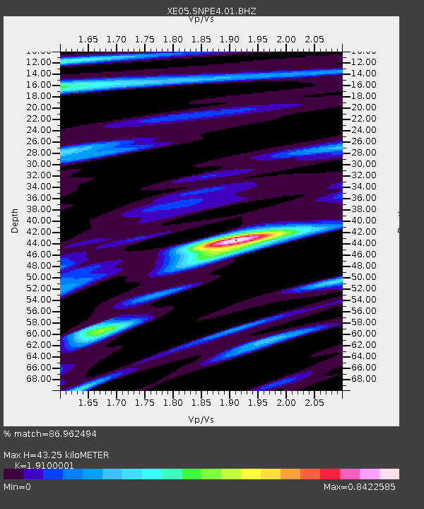
| Estimated Moho Depth: |
43.25 km |
| Estimated Crust Vp/Vs: |
1.91 |
| Assumed Crust Vp: |
6.597 km/s |
| Estimated Crust Vs: |
3.454 km/s |
| Estimated Crust Poisson's Ratio: |
0.31 |
|
| Radial Match: |
86.962494 % |
| Radial Bump: |
400 |
| Transverse Match: |
53.935234 % |
| Transverse Bump: |
400 |
| SOD ConfigId: |
268666 |
| Insert Time: |
2010-03-09 19:00:46.599 +0000 |
| GWidth: |
2.5 |
| Max Bumps: |
400 |
| Tol: |
0.001 |
|

Signal To Noise
| Channel | StoN | STA | LTA |
| XE:SNPE4:01:BHZ:20070506T21:22:21.114014Z | 48.806683 | 4.4060403E-6 | 9.027535E-8 |
| XE:SNPE4:01:BHN:20070506T21:22:21.114014Z | 11.679796 | 7.926788E-7 | 6.786752E-8 |
| XE:SNPE4:01:BHE:20070506T21:22:21.114014Z | 13.956201 | 1.199622E-6 | 8.59562E-8 |
| Arrivals |
| Ps | 6.1 SECOND |
| PpPs | 19 SECOND |
| PsPs/PpSs | 25 SECOND |


