You are here: Home > Network List > CI - Caltech Regional Seismic Network Stations List
> Station MPP McPhearson Peak > Earthquake Result Viewer
MPP McPhearson Peak - Earthquake Result Viewer
| Earthquake location: |
Near Coast Of Nicaragua |
| Earthquake latitude/longitude: |
11.5/-87.0 |
| Earthquake time(UTC): |
2022/04/21 (111) 07:42:51 GMT |
| Earthquake Depth: |
10 km |
| Earthquake Magnitude: |
6.8 Mi |
| Earthquake Catalog/Contributor: |
NEIC PDE/at |
|
| Network: |
CI Caltech Regional Seismic Network |
| Station: |
MPP McPhearson Peak |
| Lat/Lon: |
34.89 N/119.81 W |
| Elevation: |
1739 m |
|
| Distance: |
37.8 deg |
| Az: |
313.399 deg |
| Baz: |
119.964 deg |
| Ray Param: |
0.07592586 |
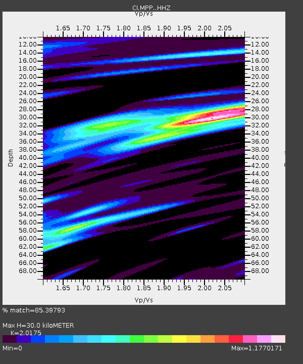
| Estimated Moho Depth: |
30.0 km |
| Estimated Crust Vp/Vs: |
2.02 |
| Assumed Crust Vp: |
6.1 km/s |
| Estimated Crust Vs: |
3.024 km/s |
| Estimated Crust Poisson's Ratio: |
0.34 |
|
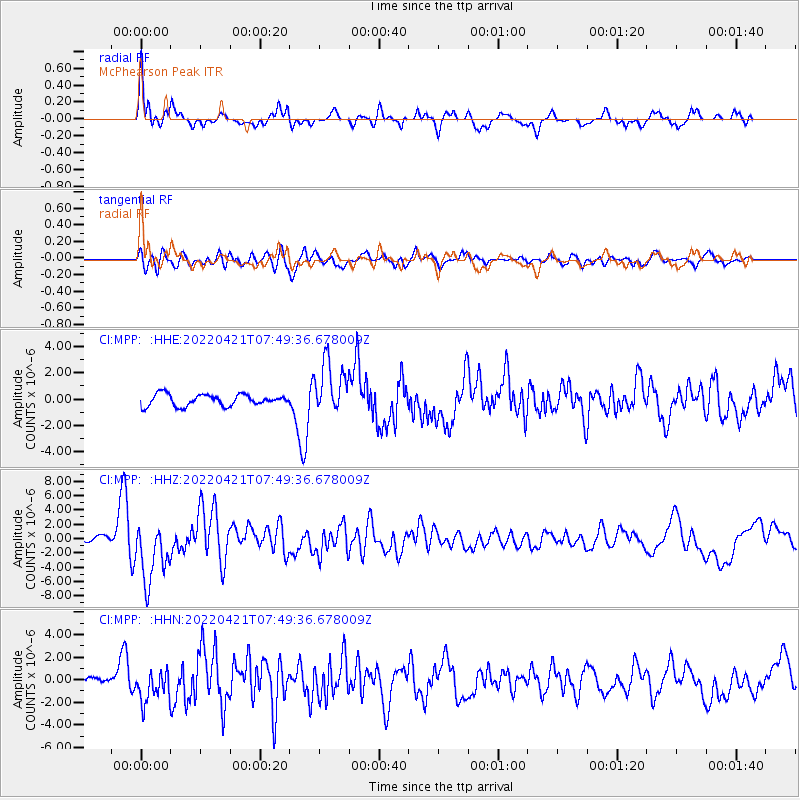
| Radial Match: |
85.39793 % |
| Radial Bump: |
400 |
| Transverse Match: |
69.069305 % |
| Transverse Bump: |
400 |
| SOD ConfigId: |
27527651 |
| Insert Time: |
2022-05-05 07:57:28.100 +0000 |
| GWidth: |
2.5 |
| Max Bumps: |
400 |
| Tol: |
0.001 |
|
Signal To Noise
| Channel | StoN | STA | LTA |
| CI:MPP: :HHZ:20220421T07:49:36.678009Z | 9.601236 | 4.1894E-6 | 4.3633963E-7 |
| CI:MPP: :HHN:20220421T07:49:36.678009Z | 5.0224357 | 1.4178614E-6 | 2.8230554E-7 |
| CI:MPP: :HHE:20220421T07:49:36.678009Z | 4.6521816 | 2.022119E-6 | 4.3466034E-7 |
| Arrivals |
| Ps | 5.3 SECOND |
| PpPs | 14 SECOND |
| PsPs/PpSs | 19 SECOND |


