You are here: Home > Network List > N4 - Central and EAstern US Network Stations List
> Station I49A Point Hope, MI, USA > Earthquake Result Viewer
I49A Point Hope, MI, USA - Earthquake Result Viewer
| Earthquake location: |
Near Coast Of Nicaragua |
| Earthquake latitude/longitude: |
11.5/-87.0 |
| Earthquake time(UTC): |
2022/04/21 (111) 07:42:51 GMT |
| Earthquake Depth: |
10 km |
| Earthquake Magnitude: |
6.8 Mi |
| Earthquake Catalog/Contributor: |
NEIC PDE/at |
|
| Network: |
N4 Central and EAstern US Network |
| Station: |
I49A Point Hope, MI, USA |
| Lat/Lon: |
43.94 N/82.82 W |
| Elevation: |
217 m |
|
| Distance: |
32.5 deg |
| Az: |
5.614 deg |
| Baz: |
187.628 deg |
| Ray Param: |
0.07862766 |
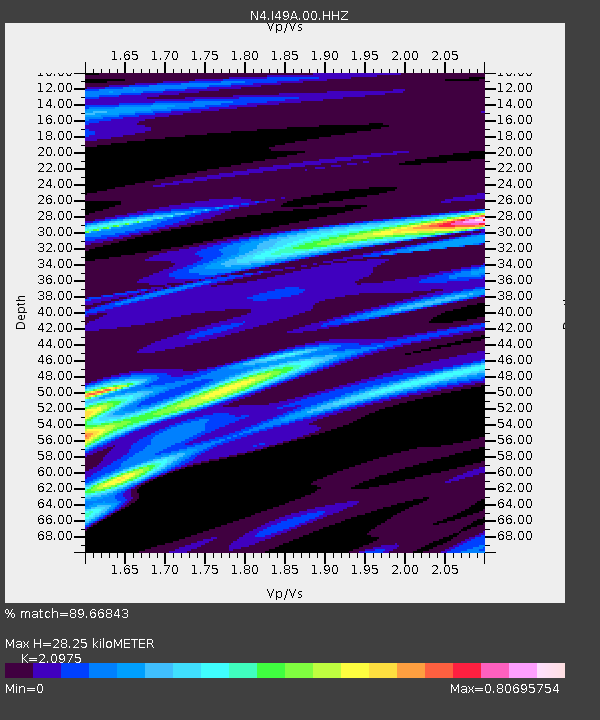
| Estimated Moho Depth: |
28.25 km |
| Estimated Crust Vp/Vs: |
2.10 |
| Assumed Crust Vp: |
6.483 km/s |
| Estimated Crust Vs: |
3.091 km/s |
| Estimated Crust Poisson's Ratio: |
0.35 |
|
| Radial Match: |
89.66843 % |
| Radial Bump: |
294 |
| Transverse Match: |
67.986336 % |
| Transverse Bump: |
400 |
| SOD ConfigId: |
27527651 |
| Insert Time: |
2022-05-05 08:06:51.085 +0000 |
| GWidth: |
2.5 |
| Max Bumps: |
400 |
| Tol: |
0.001 |
|

Signal To Noise
| Channel | StoN | STA | LTA |
| N4:I49A:00:HHZ:20220421T07:48:51.218994Z | 1.2133251 | 4.264531E-6 | 3.5147473E-6 |
| N4:I49A:00:HH1:20220421T07:48:51.218994Z | 1.4420117 | 2.751315E-6 | 1.9079698E-6 |
| N4:I49A:00:HH2:20220421T07:48:51.218994Z | 1.9112313 | 1.4020343E-6 | 7.335765E-7 |
| Arrivals |
| Ps | 5.1 SECOND |
| PpPs | 13 SECOND |
| PsPs/PpSs | 18 SECOND |


