You are here: Home > Network List > US - United States National Seismic Network Stations List
> Station AGMN Agassiz National Wildlife Refuge, Minnesota, USA > Earthquake Result Viewer
AGMN Agassiz National Wildlife Refuge, Minnesota, USA - Earthquake Result Viewer

| Earthquake location: |
Near Coast Of Nicaragua |
| Earthquake latitude/longitude: |
11.5/-87.0 |
| Earthquake time(UTC): |
2022/04/21 (111) 07:42:51 GMT |
| Earthquake Depth: |
10 km |
| Earthquake Magnitude: |
6.8 Mi |
| Earthquake Catalog/Contributor: |
NEIC PDE/at |
|
| Network: |
US United States National Seismic Network |
| Station: |
AGMN Agassiz National Wildlife Refuge, Minnesota, USA |
| Lat/Lon: |
48.30 N/95.86 W |
| Elevation: |
351 m |
|
| Distance: |
37.4 deg |
| Az: |
350.255 deg |
| Baz: |
165.613 deg |
| Ray Param: |
0.07615186 |
| Estimated Moho Depth: |
48.5 km |
| Estimated Crust Vp/Vs: |
1.66 |
| Assumed Crust Vp: |
6.419 km/s |
| Estimated Crust Vs: |
3.867 km/s |
| Estimated Crust Poisson's Ratio: |
0.22 |
|
| Radial Match: |
94.51186 % |
| Radial Bump: |
225 |
| Transverse Match: |
79.10181 % |
| Transverse Bump: |
400 |
| SOD ConfigId: |
27527651 |
| Insert Time: |
2022-05-05 08:13:08.982 +0000 |
| GWidth: |
2.5 |
| Max Bumps: |
400 |
| Tol: |
0.001 |
|
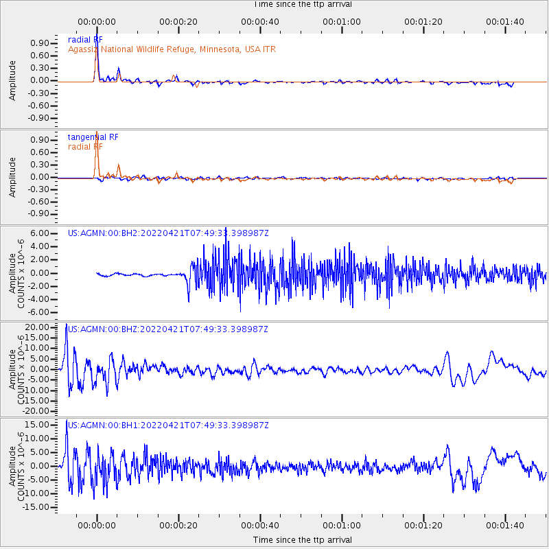
Signal To Noise
| Channel | StoN | STA | LTA |
| US:AGMN:00:BHZ:20220421T07:49:33.398987Z | 1.4870405 | 5.7606603E-6 | 3.87391E-6 |
| US:AGMN:00:BH1:20220421T07:49:33.398987Z | 1.9654572 | 5.4136844E-6 | 2.754415E-6 |
| US:AGMN:00:BH2:20220421T07:49:33.398987Z | 3.840208 | 2.5730978E-6 | 6.700413E-7 |
| Arrivals |
| Ps | 5.4 SECOND |
| PpPs | 19 SECOND |
| PsPs/PpSs | 24 SECOND |


