You are here: Home > Network List > US - United States National Seismic Network Stations List
> Station EGMT Eagleton, Montana, USA > Earthquake Result Viewer
EGMT Eagleton, Montana, USA - Earthquake Result Viewer
| Earthquake location: |
Near Coast Of Nicaragua |
| Earthquake latitude/longitude: |
11.5/-87.0 |
| Earthquake time(UTC): |
2022/04/21 (111) 07:42:51 GMT |
| Earthquake Depth: |
10 km |
| Earthquake Magnitude: |
6.8 Mi |
| Earthquake Catalog/Contributor: |
NEIC PDE/at |
|
| Network: |
US United States National Seismic Network |
| Station: |
EGMT Eagleton, Montana, USA |
| Lat/Lon: |
48.02 N/109.75 W |
| Elevation: |
1055 m |
|
| Distance: |
41.1 deg |
| Az: |
336.734 deg |
| Baz: |
144.777 deg |
| Ray Param: |
0.07400648 |
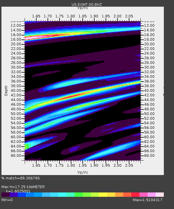
| Estimated Moho Depth: |
17.25 km |
| Estimated Crust Vp/Vs: |
1.60 |
| Assumed Crust Vp: |
6.438 km/s |
| Estimated Crust Vs: |
4.017 km/s |
| Estimated Crust Poisson's Ratio: |
0.18 |
|
| Radial Match: |
89.386765 % |
| Radial Bump: |
285 |
| Transverse Match: |
75.2824 % |
| Transverse Bump: |
400 |
| SOD ConfigId: |
27527651 |
| Insert Time: |
2022-05-05 08:13:22.293 +0000 |
| GWidth: |
2.5 |
| Max Bumps: |
400 |
| Tol: |
0.001 |
|
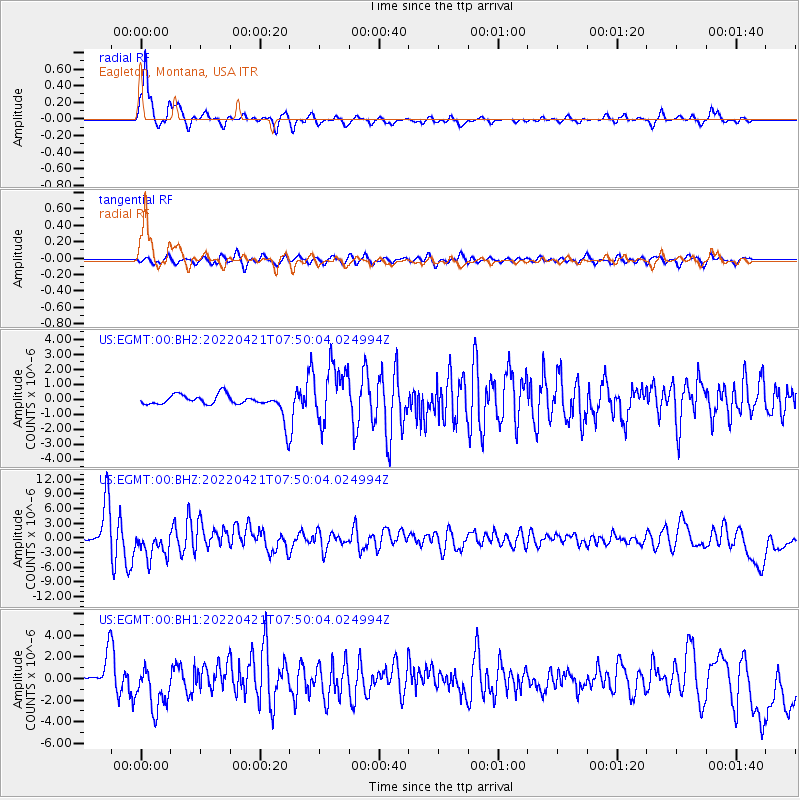
Signal To Noise
| Channel | StoN | STA | LTA |
| US:EGMT:00:BHZ:20220421T07:50:04.024994Z | 1.3897256 | 3.163386E-6 | 2.2762667E-6 |
| US:EGMT:00:BH1:20220421T07:50:04.024994Z | 2.7889903 | 2.108782E-6 | 7.5610944E-7 |
| US:EGMT:00:BH2:20220421T07:50:04.024994Z | 3.3683197 | 1.9322658E-6 | 5.7365867E-7 |
| Arrivals |
| Ps | 1.7 SECOND |
| PpPs | 6.5 SECOND |
| PsPs/PpSs | 8.2 SECOND |


