You are here: Home > Network List > US - United States National Seismic Network Stations List
> Station ERPA Erie, Pennsylvania, USA > Earthquake Result Viewer
ERPA Erie, Pennsylvania, USA - Earthquake Result Viewer
| Earthquake location: |
Near Coast Of Nicaragua |
| Earthquake latitude/longitude: |
11.5/-87.0 |
| Earthquake time(UTC): |
2022/04/21 (111) 07:42:51 GMT |
| Earthquake Depth: |
10 km |
| Earthquake Magnitude: |
6.8 Mi |
| Earthquake Catalog/Contributor: |
NEIC PDE/at |
|
| Network: |
US United States National Seismic Network |
| Station: |
ERPA Erie, Pennsylvania, USA |
| Lat/Lon: |
42.12 N/79.99 W |
| Elevation: |
306 m |
|
| Distance: |
31.1 deg |
| Az: |
10.123 deg |
| Baz: |
193.388 deg |
| Ray Param: |
0.0791973 |
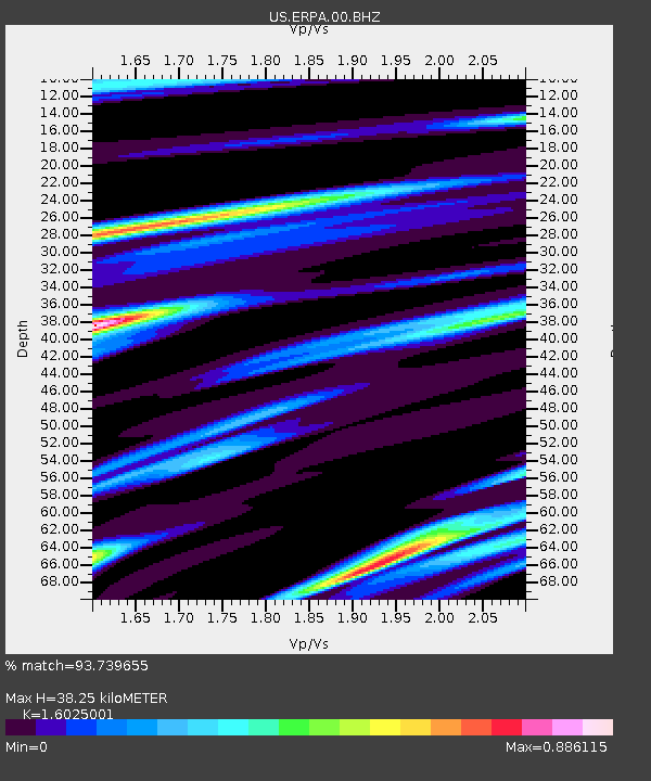
| Estimated Moho Depth: |
38.25 km |
| Estimated Crust Vp/Vs: |
1.60 |
| Assumed Crust Vp: |
6.419 km/s |
| Estimated Crust Vs: |
4.006 km/s |
| Estimated Crust Poisson's Ratio: |
0.18 |
|
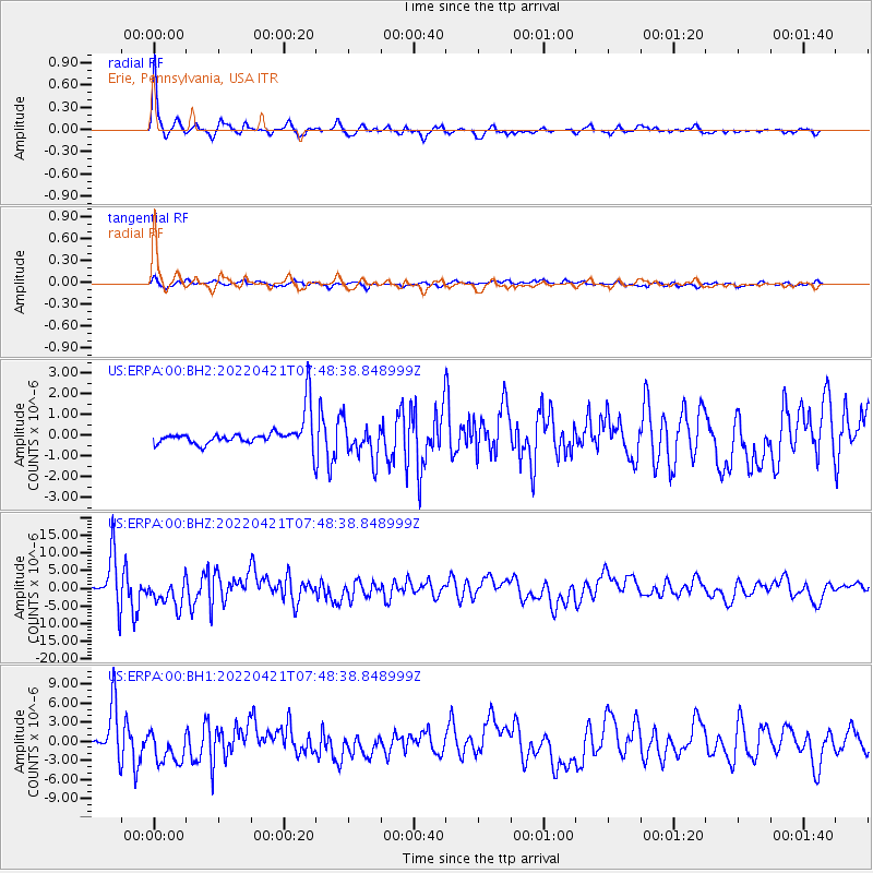
| Radial Match: |
93.739655 % |
| Radial Bump: |
383 |
| Transverse Match: |
69.581955 % |
| Transverse Bump: |
400 |
| SOD ConfigId: |
27527651 |
| Insert Time: |
2022-05-05 08:13:26.070 +0000 |
| GWidth: |
2.5 |
| Max Bumps: |
400 |
| Tol: |
0.001 |
|
Signal To Noise
| Channel | StoN | STA | LTA |
| US:ERPA:00:BHZ:20220421T07:48:38.848999Z | 1.2174397 | 4.0350824E-6 | 3.3144004E-6 |
| US:ERPA:00:BH1:20220421T07:48:38.848999Z | 1.3827472 | 2.6348698E-6 | 1.9055326E-6 |
| US:ERPA:00:BH2:20220421T07:48:38.848999Z | 1.397431 | 8.8508045E-7 | 6.333625E-7 |
| Arrivals |
| Ps | 3.9 SECOND |
| PpPs | 14 SECOND |
| PsPs/PpSs | 18 SECOND |


