You are here: Home > Network List > IU - Global Seismograph Network (GSN - IRIS/USGS) Stations List
> Station JOHN Johnston Island, USA > Earthquake Result Viewer
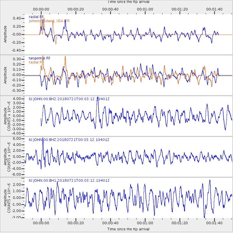
JOHN Johnston Island, USA - Earthquake Result Viewer
*The percent match for this event was below the threshold and hence no stack was calculated.
| Earthquake location: |
Mariana Islands |
| Earthquake latitude/longitude: |
18.5/146.0 |
| Earthquake time(UTC): |
2018/07/20 (201) 23:56:00 GMT |
| Earthquake Depth: |
126 km |
| Earthquake Magnitude: |
5.6 Mww |
| Earthquake Catalog/Contributor: |
NEIC PDE/us |
|
| Network: |
IU Global Seismograph Network (GSN - IRIS/USGS) |
| Station: |
JOHN Johnston Island, USA |
| Lat/Lon: |
16.73 N/169.53 W |
| Elevation: |
2.0 m |
|
| Distance: |
42.3 deg |
| Az: |
85.209 deg |
| Baz: |
279.221 deg |
| Ray Param: |
$rayparam |
*The percent match for this event was below the threshold and hence was not used in the summary stack. |
|
| Radial Match: |
63.836796 % |
| Radial Bump: |
344 |
| Transverse Match: |
57.510403 % |
| Transverse Bump: |
400 |
| SOD ConfigId: |
2778632 |
| Insert Time: |
2018-08-03 23:58:33.883 +0000 |
| GWidth: |
2.5 |
| Max Bumps: |
400 |
| Tol: |
0.001 |
|
Signal To Noise
| Channel | StoN | STA | LTA |
| IU:JOHN:00:BHZ:20180721T00:03:12.19401Z | 2.4169464 | 2.4691112E-6 | 1.021583E-6 |
| IU:JOHN:00:BH1:20180721T00:03:12.19401Z | 1.1360594 | 1.0195981E-6 | 8.9748664E-7 |
| IU:JOHN:00:BH2:20180721T00:03:12.19401Z | 1.8757521 | 2.0917737E-6 | 1.1151653E-6 |
| Arrivals |
| Ps | |
| PpPs | |
| PsPs/PpSs | |


