You are here: Home > Network List > IW - Intermountain West Stations List
> Station MOOW Moose Ponds, Wyoming, USA > Earthquake Result Viewer
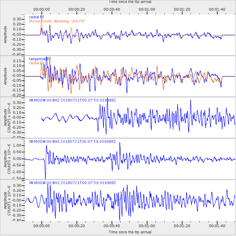
MOOW Moose Ponds, Wyoming, USA - Earthquake Result Viewer
*The percent match for this event was below the threshold and hence no stack was calculated.
| Earthquake location: |
Mariana Islands |
| Earthquake latitude/longitude: |
18.5/146.0 |
| Earthquake time(UTC): |
2018/07/20 (201) 23:56:00 GMT |
| Earthquake Depth: |
126 km |
| Earthquake Magnitude: |
5.6 Mww |
| Earthquake Catalog/Contributor: |
NEIC PDE/us |
|
| Network: |
IW Intermountain West |
| Station: |
MOOW Moose Ponds, Wyoming, USA |
| Lat/Lon: |
43.75 N/110.74 W |
| Elevation: |
2128 m |
|
| Distance: |
86.6 deg |
| Az: |
44.961 deg |
| Baz: |
292.263 deg |
| Ray Param: |
$rayparam |
*The percent match for this event was below the threshold and hence was not used in the summary stack. |
|
| Radial Match: |
69.42309 % |
| Radial Bump: |
400 |
| Transverse Match: |
73.54054 % |
| Transverse Bump: |
400 |
| SOD ConfigId: |
2778632 |
| Insert Time: |
2018-08-03 23:59:13.657 +0000 |
| GWidth: |
2.5 |
| Max Bumps: |
400 |
| Tol: |
0.001 |
|
Signal To Noise
| Channel | StoN | STA | LTA |
| IW:MOOW:00:BHZ:20180721T00:07:59.039988Z | 7.3717756 | 5.1082714E-7 | 6.929499E-8 |
| IW:MOOW:00:BH1:20180721T00:07:59.039988Z | 3.8767796 | 1.1956172E-7 | 3.0840475E-8 |
| IW:MOOW:00:BH2:20180721T00:07:59.039988Z | 2.9029248 | 1.13365466E-7 | 3.9052154E-8 |
| Arrivals |
| Ps | |
| PpPs | |
| PsPs/PpSs | |


