You are here: Home > Network List > IW - Intermountain West Stations List
> Station MOOW Moose Ponds, Wyoming, USA > Earthquake Result Viewer
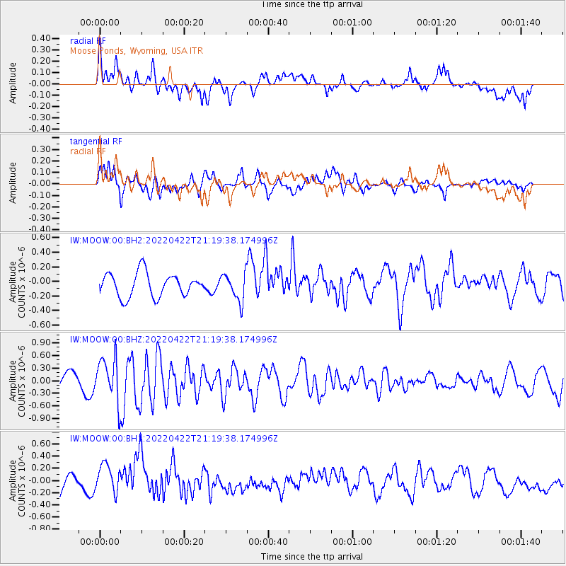
MOOW Moose Ponds, Wyoming, USA - Earthquake Result Viewer
*The percent match for this event was below the threshold and hence no stack was calculated.
| Earthquake location: |
Northwestern Balkan Region |
| Earthquake latitude/longitude: |
43.1/18.2 |
| Earthquake time(UTC): |
2022/04/22 (112) 21:07:48 GMT |
| Earthquake Depth: |
10 km |
| Earthquake Magnitude: |
5.7 mww |
| Earthquake Catalog/Contributor: |
NEIC PDE/us |
|
| Network: |
IW Intermountain West |
| Station: |
MOOW Moose Ponds, Wyoming, USA |
| Lat/Lon: |
43.75 N/110.74 W |
| Elevation: |
2128 m |
|
| Distance: |
82.2 deg |
| Az: |
325.316 deg |
| Baz: |
35.134 deg |
| Ray Param: |
$rayparam |
*The percent match for this event was below the threshold and hence was not used in the summary stack. |
|
| Radial Match: |
64.14145 % |
| Radial Bump: |
400 |
| Transverse Match: |
67.712296 % |
| Transverse Bump: |
400 |
| SOD ConfigId: |
27527651 |
| Insert Time: |
2022-05-06 21:24:06.189 +0000 |
| GWidth: |
2.5 |
| Max Bumps: |
400 |
| Tol: |
0.001 |
|
Signal To Noise
| Channel | StoN | STA | LTA |
| IW:MOOW:00:BHZ:20220422T21:19:38.174996Z | 2.2407372 | 5.3535763E-7 | 2.389203E-7 |
| IW:MOOW:00:BH1:20220422T21:19:38.174996Z | 1.0365999 | 2.2747402E-7 | 2.1944244E-7 |
| IW:MOOW:00:BH2:20220422T21:19:38.174996Z | 1.2227734 | 1.9694916E-7 | 1.6106758E-7 |
| Arrivals |
| Ps | |
| PpPs | |
| PsPs/PpSs | |


