You are here: Home > Network List > TX - Texas Seismological Network Stations List
> Station 435B Jarrell, TX, USA > Earthquake Result Viewer
435B Jarrell, TX, USA - Earthquake Result Viewer
| Earthquake location: |
Northwestern Balkan Region |
| Earthquake latitude/longitude: |
43.1/18.2 |
| Earthquake time(UTC): |
2022/04/22 (112) 21:07:48 GMT |
| Earthquake Depth: |
10 km |
| Earthquake Magnitude: |
5.7 mww |
| Earthquake Catalog/Contributor: |
NEIC PDE/us |
|
| Network: |
TX Texas Seismological Network |
| Station: |
435B Jarrell, TX, USA |
| Lat/Lon: |
30.78 N/97.58 W |
| Elevation: |
248 m |
|
| Distance: |
85.9 deg |
| Az: |
309.002 deg |
| Baz: |
41.438 deg |
| Ray Param: |
0.04447071 |
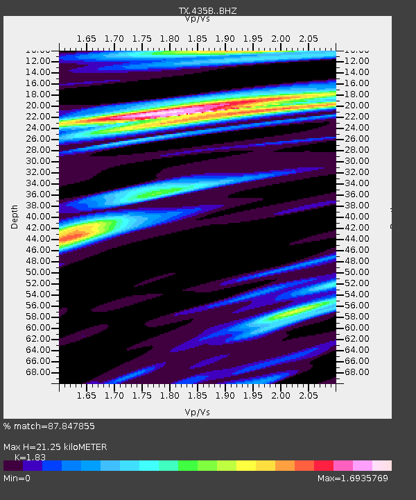
| Estimated Moho Depth: |
21.25 km |
| Estimated Crust Vp/Vs: |
1.83 |
| Assumed Crust Vp: |
6.347 km/s |
| Estimated Crust Vs: |
3.468 km/s |
| Estimated Crust Poisson's Ratio: |
0.29 |
|
| Radial Match: |
87.847855 % |
| Radial Bump: |
400 |
| Transverse Match: |
83.13544 % |
| Transverse Bump: |
400 |
| SOD ConfigId: |
27527651 |
| Insert Time: |
2022-05-06 21:35:47.712 +0000 |
| GWidth: |
2.5 |
| Max Bumps: |
400 |
| Tol: |
0.001 |
|

Signal To Noise
| Channel | StoN | STA | LTA |
| TX:435B: :BHZ:20220422T21:19:56.523995Z | 3.5246868 | 7.4801534E-7 | 2.1222178E-7 |
| TX:435B: :BHN:20220422T21:19:56.523995Z | 3.171819 | 3.5792223E-7 | 1.1284447E-7 |
| TX:435B: :BHE:20220422T21:19:56.523995Z | 1.7794918 | 3.474759E-7 | 1.9526694E-7 |
| Arrivals |
| Ps | 2.8 SECOND |
| PpPs | 9.3 SECOND |
| PsPs/PpSs | 12 SECOND |


