You are here: Home > Network List > AC - Albanian Seismological Network Stations List
> Station BCI Bajram Curri, Albania > Earthquake Result Viewer
BCI Bajram Curri, Albania - Earthquake Result Viewer
| Earthquake location: |
Kuril Islands |
| Earthquake latitude/longitude: |
46.0/152.8 |
| Earthquake time(UTC): |
2022/04/24 (114) 01:35:01 GMT |
| Earthquake Depth: |
20 km |
| Earthquake Magnitude: |
5.7 Mww |
| Earthquake Catalog/Contributor: |
NEIC PDE/us |
|
| Network: |
AC Albanian Seismological Network |
| Station: |
BCI Bajram Curri, Albania |
| Lat/Lon: |
42.37 N/20.07 E |
| Elevation: |
500 m |
|
| Distance: |
82.5 deg |
| Az: |
326.685 deg |
| Baz: |
31.086 deg |
| Ray Param: |
0.046861812 |
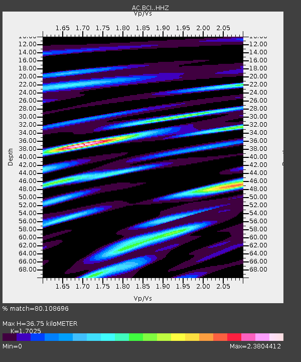
| Estimated Moho Depth: |
36.75 km |
| Estimated Crust Vp/Vs: |
1.70 |
| Assumed Crust Vp: |
6.291 km/s |
| Estimated Crust Vs: |
3.695 km/s |
| Estimated Crust Poisson's Ratio: |
0.24 |
|
| Radial Match: |
80.108696 % |
| Radial Bump: |
400 |
| Transverse Match: |
76.01778 % |
| Transverse Bump: |
400 |
| SOD ConfigId: |
27527651 |
| Insert Time: |
2022-05-08 01:37:00.803 +0000 |
| GWidth: |
2.5 |
| Max Bumps: |
400 |
| Tol: |
0.001 |
|

Signal To Noise
| Channel | StoN | STA | LTA |
| AC:BCI: :HHZ:20220424T01:46:50.570023Z | 13.548393 | 2.1449289E-6 | 1.5831611E-7 |
| AC:BCI: :HHN:20220424T01:46:50.570023Z | 5.462063 | 7.265457E-7 | 1.3301671E-7 |
| AC:BCI: :HHE:20220424T01:46:50.570023Z | 6.8114743 | 7.02001E-7 | 1.0306154E-7 |
| Arrivals |
| Ps | 4.2 SECOND |
| PpPs | 15 SECOND |
| PsPs/PpSs | 20 SECOND |


