You are here: Home > Network List > XE05 - Sierra Nevada EarthScope Project- EarthScope Flex Array Stations List
> Station SNPE6 SNPE6 > Earthquake Result Viewer
SNPE6 SNPE6 - Earthquake Result Viewer
| Earthquake location: |
Solomon Islands |
| Earthquake latitude/longitude: |
-7.3/155.6 |
| Earthquake time(UTC): |
2007/04/01 (091) 21:45:37 GMT |
| Earthquake Depth: |
10 km |
| Earthquake Magnitude: |
5.7 MB |
| Earthquake Catalog/Contributor: |
WHDF/NEIC |
|
| Network: |
XE Sierra Nevada EarthScope Project- EarthScope Flex Array |
| Station: |
SNPE6 SNPE6 |
| Lat/Lon: |
39.48 N/120.85 W |
| Elevation: |
1479 m |
|
| Distance: |
89.6 deg |
| Az: |
50.265 deg |
| Baz: |
260.266 deg |
| Ray Param: |
0.04173138 |
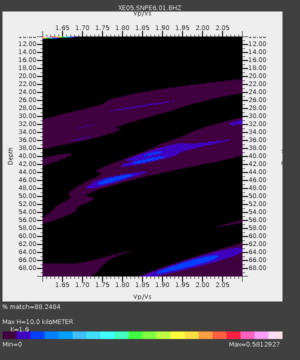
| Estimated Moho Depth: |
10.0 km |
| Estimated Crust Vp/Vs: |
1.60 |
| Assumed Crust Vp: |
6.597 km/s |
| Estimated Crust Vs: |
4.123 km/s |
| Estimated Crust Poisson's Ratio: |
0.18 |
|
| Radial Match: |
88.2484 % |
| Radial Bump: |
366 |
| Transverse Match: |
88.74042 % |
| Transverse Bump: |
400 |
| SOD ConfigId: |
268666 |
| Insert Time: |
2010-03-09 19:09:43.927 +0000 |
| GWidth: |
2.5 |
| Max Bumps: |
400 |
| Tol: |
0.001 |
|

Signal To Noise
| Channel | StoN | STA | LTA |
| XE:SNPE6:01:BHZ:20070401T21:58:03.889001Z | 1.0795699 | 3.9333983E-5 | 3.6434863E-5 |
| XE:SNPE6:01:BHN:20070401T21:58:03.889001Z | 1.7020477 | 2.453068E-5 | 1.44124515E-5 |
| XE:SNPE6:01:BHE:20070401T21:58:03.889001Z | 1.7766968 | 1.6500762E-5 | 9.287326E-6 |
| Arrivals |
| Ps | 0.9 SECOND |
| PpPs | 3.8 SECOND |
| PsPs/PpSs | 4.8 SECOND |


