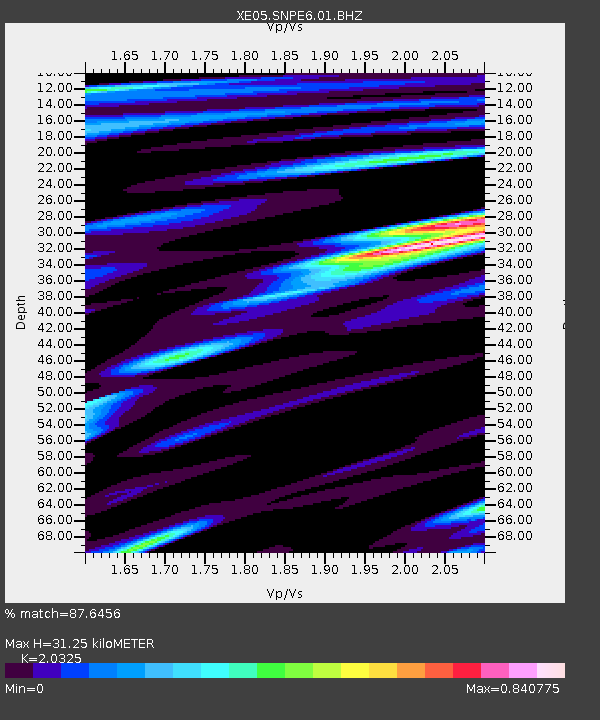
SNPE6 SNPE6 - Earthquake Result Viewer

Earthquake location: Loyalty Islands
Earthquake latitude/longitude: -20.7/168.8
Earthquake time(UTC): 2007/04/04 (094) 11:00:27 GMT
Earthquake Depth: 10 km
Earthquake Magnitude: 5.8 MB, 6.4 MS, 6.2 MW, 6.1 MW
Earthquake Catalog/Contributor: WHDF/NEIC
Network: XE Sierra Nevada EarthScope Project- EarthScope Flex Array
Station: SNPE6 SNPE6
Lat/Lon: 39.48 N/120.85 W
Elevation: 1479 m
Distance: 88.8 deg
Az: 46.798 deg
Baz: 241.849 deg
Ray Param: 0.042331643
Estimated Moho Depth: 31.25 km
Estimated Crust Vp/Vs: 2.03
Assumed Crust Vp: 6.597 km/s
Estimated Crust Vs: 3.246 km/s
Estimated Crust Poisson's Ratio: 0.34
Radial Match: 87.6456 %
Radial Bump: 400
Transverse Match: 81.92596 %
Transverse Bump: 400
SOD ConfigId: 268666
Insert Time: 2010-03-09 19:09:46.068 +0000
GWidth: 2.5
Max Bumps: 400
Tol: 0.001

Signal To Noise

ChannelStoNSTALTA
XE:SNPE6:01:BHZ:20070404T11:12:49.765012Z4.87947278.580739E-71.7585381E-7
XE:SNPE6:01:BHN:20070404T11:12:49.765012Z1.18305171.1799168E-79.9735026E-8
XE:SNPE6:01:BHE:20070404T11:12:49.765012Z1.89945423.2614344E-71.7170376E-7
Arrivals
Ps5.0 SECOND
PpPs14 SECOND
PsPs/PpSs19 SECOND