You are here: Home > Network List > SC - New Mexico Tech Seismic Network Stations List
> Station GDL2 Guadalupe Mountains, New Mexico > Earthquake Result Viewer
GDL2 Guadalupe Mountains, New Mexico - Earthquake Result Viewer
| Earthquake location: |
Kuril Islands |
| Earthquake latitude/longitude: |
46.0/152.8 |
| Earthquake time(UTC): |
2022/04/24 (114) 01:35:01 GMT |
| Earthquake Depth: |
20 km |
| Earthquake Magnitude: |
5.7 Mww |
| Earthquake Catalog/Contributor: |
NEIC PDE/us |
|
| Network: |
SC New Mexico Tech Seismic Network |
| Station: |
GDL2 Guadalupe Mountains, New Mexico |
| Lat/Lon: |
32.20 N/104.36 W |
| Elevation: |
1211 m |
|
| Distance: |
75.6 deg |
| Az: |
58.59 deg |
| Baz: |
315.464 deg |
| Ray Param: |
0.051564325 |
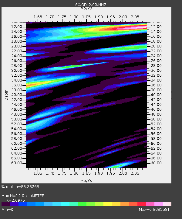
| Estimated Moho Depth: |
12.0 km |
| Estimated Crust Vp/Vs: |
2.10 |
| Assumed Crust Vp: |
6.232 km/s |
| Estimated Crust Vs: |
2.971 km/s |
| Estimated Crust Poisson's Ratio: |
0.35 |
|
| Radial Match: |
88.38268 % |
| Radial Bump: |
400 |
| Transverse Match: |
81.18795 % |
| Transverse Bump: |
400 |
| SOD ConfigId: |
27527651 |
| Insert Time: |
2022-05-08 02:00:29.502 +0000 |
| GWidth: |
2.5 |
| Max Bumps: |
400 |
| Tol: |
0.001 |
|

Signal To Noise
| Channel | StoN | STA | LTA |
| SC:GDL2:00:HHZ:20220424T01:46:13.044999Z | 8.890882 | 3.78589E-8 | 4.2581716E-9 |
| SC:GDL2:00:HHN:20220424T01:46:13.044999Z | 2.9545426 | 1.0728285E-8 | 3.6311154E-9 |
| SC:GDL2:00:HHE:20220424T01:46:13.044999Z | 2.1985412 | 8.164948E-9 | 3.7138026E-9 |
| Arrivals |
| Ps | 2.2 SECOND |
| PpPs | 5.8 SECOND |
| PsPs/PpSs | 8.0 SECOND |


