You are here: Home > Network List > AK - Alaska Regional Network Stations List
> Station L19K White Mountain, AK, USA > Earthquake Result Viewer
L19K White Mountain, AK, USA - Earthquake Result Viewer
| Earthquake location: |
Bismarck Sea |
| Earthquake latitude/longitude: |
-4.0/146.7 |
| Earthquake time(UTC): |
2022/04/28 (118) 13:21:13 GMT |
| Earthquake Depth: |
10 km |
| Earthquake Magnitude: |
6.0 mww |
| Earthquake Catalog/Contributor: |
NEIC PDE/us |
|
| Network: |
AK Alaska Regional Network |
| Station: |
L19K White Mountain, AK, USA |
| Lat/Lon: |
62.18 N/154.85 W |
| Elevation: |
650 m |
|
| Distance: |
79.4 deg |
| Az: |
24.01 deg |
| Baz: |
239.919 deg |
| Ray Param: |
0.04900178 |
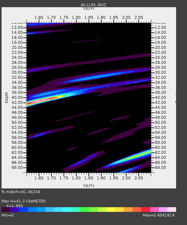
| Estimated Moho Depth: |
41.0 km |
| Estimated Crust Vp/Vs: |
1.65 |
| Assumed Crust Vp: |
6.438 km/s |
| Estimated Crust Vs: |
3.89 km/s |
| Estimated Crust Poisson's Ratio: |
0.21 |
|
| Radial Match: |
81.46244 % |
| Radial Bump: |
400 |
| Transverse Match: |
65.34725 % |
| Transverse Bump: |
400 |
| SOD ConfigId: |
27527651 |
| Insert Time: |
2022-05-12 13:25:00.650 +0000 |
| GWidth: |
2.5 |
| Max Bumps: |
400 |
| Tol: |
0.001 |
|

Signal To Noise
| Channel | StoN | STA | LTA |
| AK:L19K: :BHZ:20220428T13:32:47.960021Z | 2.2513056 | 2.434892E-7 | 1.0815467E-7 |
| AK:L19K: :BHN:20220428T13:32:47.960021Z | 1.2126875 | 7.85956E-8 | 6.481109E-8 |
| AK:L19K: :BHE:20220428T13:32:47.960021Z | 1.1056509 | 8.9172765E-8 | 8.065182E-8 |
| Arrivals |
| Ps | 4.3 SECOND |
| PpPs | 16 SECOND |
| PsPs/PpSs | 21 SECOND |


