You are here: Home > Network List > XE05 - Sierra Nevada EarthScope Project- EarthScope Flex Array Stations List
> Station SNPE7 SNPE7 > Earthquake Result Viewer
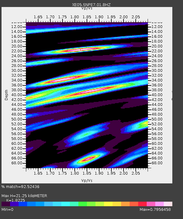
SNPE7 SNPE7 - Earthquake Result Viewer
| Earthquake location: |
Chile-Argentina Border Region |
| Earthquake latitude/longitude: |
-24.4/-67.0 |
| Earthquake time(UTC): |
2006/08/25 (237) 00:44:46 GMT |
| Earthquake Depth: |
184 km |
| Earthquake Magnitude: |
5.9 MB, 6.6 MW, 6.6 MW |
| Earthquake Catalog/Contributor: |
WHDF/NEIC |
|
| Network: |
XE Sierra Nevada EarthScope Project- EarthScope Flex Array |
| Station: |
SNPE7 SNPE7 |
| Lat/Lon: |
39.80 N/120.71 W |
| Elevation: |
1537 m |
|
| Distance: |
81.1 deg |
| Az: |
321.081 deg |
| Baz: |
131.971 deg |
| Ray Param: |
0.047337115 |
| Estimated Moho Depth: |
21.25 km |
| Estimated Crust Vp/Vs: |
1.82 |
| Assumed Crust Vp: |
6.597 km/s |
| Estimated Crust Vs: |
3.62 km/s |
| Estimated Crust Poisson's Ratio: |
0.28 |
|
| Radial Match: |
92.52436 % |
| Radial Bump: |
400 |
| Transverse Match: |
83.191475 % |
| Transverse Bump: |
400 |
| SOD ConfigId: |
268666 |
| Insert Time: |
2010-03-09 19:13:39.299 +0000 |
| GWidth: |
2.5 |
| Max Bumps: |
400 |
| Tol: |
0.001 |
|

Signal To Noise
| Channel | StoN | STA | LTA |
| XE:SNPE7:01:BHZ:20060825T00:56:09.898994Z | 32.651203 | 2.1852056E-6 | 6.692573E-8 |
| XE:SNPE7:01:BHN:20060825T00:56:09.898994Z | 4.5534844 | 4.8366235E-7 | 1.0621807E-7 |
| XE:SNPE7:01:BHE:20060825T00:56:09.898994Z | 6.0884676 | 7.187637E-7 | 1.1805331E-7 |
| Arrivals |
| Ps | 2.7 SECOND |
| PpPs | 8.8 SECOND |
| PsPs/PpSs | 12 SECOND |


