You are here: Home > Network List > AV - Alaska Volcano Observatory Stations List
> Station KAHG Katmai Hook Glacier, Alaska > Earthquake Result Viewer
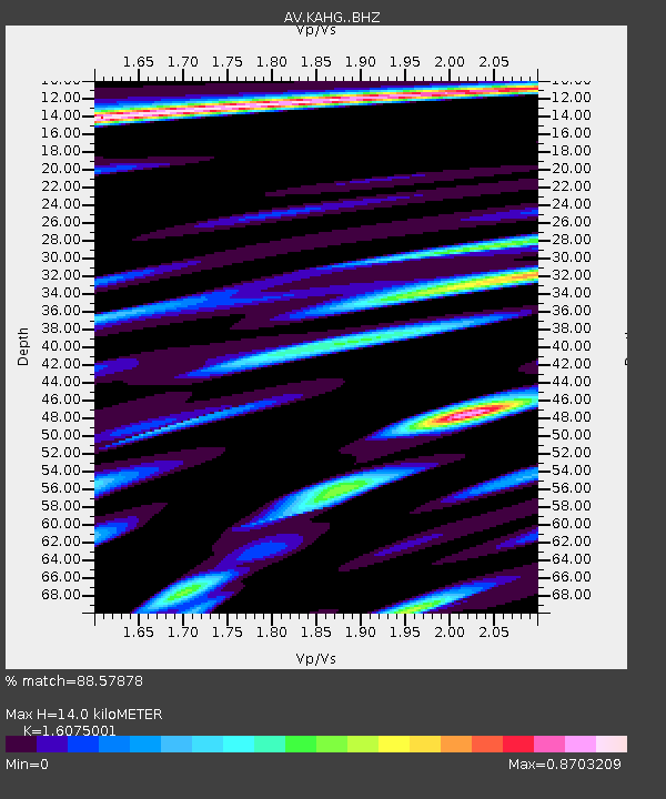
KAHG Katmai Hook Glacier, Alaska - Earthquake Result Viewer
| Earthquake location: |
Bismarck Sea |
| Earthquake latitude/longitude: |
-4.0/146.7 |
| Earthquake time(UTC): |
2022/04/28 (118) 13:21:13 GMT |
| Earthquake Depth: |
10 km |
| Earthquake Magnitude: |
6.0 mww |
| Earthquake Catalog/Contributor: |
NEIC PDE/us |
|
| Network: |
AV Alaska Volcano Observatory |
| Station: |
KAHG Katmai Hook Glacier, Alaska |
| Lat/Lon: |
58.49 N/154.55 W |
| Elevation: |
923 m |
|
| Distance: |
77.7 deg |
| Az: |
27.37 deg |
| Baz: |
240.852 deg |
| Ray Param: |
0.05016238 |
| Estimated Moho Depth: |
14.0 km |
| Estimated Crust Vp/Vs: |
1.61 |
| Assumed Crust Vp: |
6.438 km/s |
| Estimated Crust Vs: |
4.005 km/s |
| Estimated Crust Poisson's Ratio: |
0.18 |
|
| Radial Match: |
88.57878 % |
| Radial Bump: |
400 |
| Transverse Match: |
85.12835 % |
| Transverse Bump: |
400 |
| SOD ConfigId: |
27527651 |
| Insert Time: |
2022-05-12 13:27:53.106 +0000 |
| GWidth: |
2.5 |
| Max Bumps: |
400 |
| Tol: |
0.001 |
|

Signal To Noise
| Channel | StoN | STA | LTA |
| AV:KAHG: :BHZ:20220428T13:32:38.640014Z | 3.8468995 | 2.3165414E-7 | 6.0218404E-8 |
| AV:KAHG: :BHN:20220428T13:32:38.640014Z | 1.3142678 | 7.7077665E-8 | 5.8646854E-8 |
| AV:KAHG: :BHE:20220428T13:32:38.640014Z | 1.5306376 | 1.0594302E-7 | 6.921496E-8 |
| Arrivals |
| Ps | 1.4 SECOND |
| PpPs | 5.5 SECOND |
| PsPs/PpSs | 6.8 SECOND |


