You are here: Home > Network List > AV - Alaska Volcano Observatory Stations List
> Station KAWH Katmai, Alaska > Earthquake Result Viewer
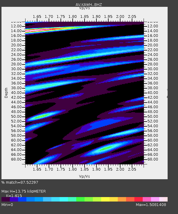
KAWH Katmai, Alaska - Earthquake Result Viewer
| Earthquake location: |
Bismarck Sea |
| Earthquake latitude/longitude: |
-4.0/146.7 |
| Earthquake time(UTC): |
2022/04/28 (118) 13:21:13 GMT |
| Earthquake Depth: |
10 km |
| Earthquake Magnitude: |
6.0 mww |
| Earthquake Catalog/Contributor: |
NEIC PDE/us |
|
| Network: |
AV Alaska Volcano Observatory |
| Station: |
KAWH Katmai, Alaska |
| Lat/Lon: |
58.38 N/154.80 W |
| Elevation: |
777 m |
|
| Distance: |
77.5 deg |
| Az: |
27.402 deg |
| Baz: |
240.644 deg |
| Ray Param: |
0.050275013 |
| Estimated Moho Depth: |
13.75 km |
| Estimated Crust Vp/Vs: |
1.62 |
| Assumed Crust Vp: |
6.438 km/s |
| Estimated Crust Vs: |
3.987 km/s |
| Estimated Crust Poisson's Ratio: |
0.19 |
|
| Radial Match: |
87.52297 % |
| Radial Bump: |
400 |
| Transverse Match: |
82.314705 % |
| Transverse Bump: |
400 |
| SOD ConfigId: |
27527651 |
| Insert Time: |
2022-05-12 13:28:00.543 +0000 |
| GWidth: |
2.5 |
| Max Bumps: |
400 |
| Tol: |
0.001 |
|

Signal To Noise
| Channel | StoN | STA | LTA |
| AV:KAWH: :BHZ:20220428T13:32:37.700012Z | 4.1405425 | 2.1237926E-7 | 5.129262E-8 |
| AV:KAWH: :BHN:20220428T13:32:37.700012Z | 1.8451533 | 6.203453E-8 | 3.3620257E-8 |
| AV:KAWH: :BHE:20220428T13:32:37.700012Z | 3.0871913 | 1.2550329E-7 | 4.0652903E-8 |
| Arrivals |
| Ps | 1.4 SECOND |
| PpPs | 5.4 SECOND |
| PsPs/PpSs | 6.8 SECOND |


