You are here: Home > Network List > PS - Pacific21 Stations List
> Station PSI Parapat, Indonesia > Earthquake Result Viewer
PSI Parapat, Indonesia - Earthquake Result Viewer
| Earthquake location: |
Bismarck Sea |
| Earthquake latitude/longitude: |
-4.0/146.7 |
| Earthquake time(UTC): |
2022/04/28 (118) 13:21:13 GMT |
| Earthquake Depth: |
10 km |
| Earthquake Magnitude: |
6.0 mww |
| Earthquake Catalog/Contributor: |
NEIC PDE/us |
|
| Network: |
PS Pacific21 |
| Station: |
PSI Parapat, Indonesia |
| Lat/Lon: |
2.69 N/98.92 E |
| Elevation: |
987 m |
|
| Distance: |
48.2 deg |
| Az: |
277.137 deg |
| Baz: |
97.691 deg |
| Ray Param: |
0.06954721 |
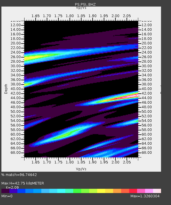
| Estimated Moho Depth: |
42.75 km |
| Estimated Crust Vp/Vs: |
2.09 |
| Assumed Crust Vp: |
6.468 km/s |
| Estimated Crust Vs: |
3.095 km/s |
| Estimated Crust Poisson's Ratio: |
0.35 |
|
| Radial Match: |
96.74642 % |
| Radial Bump: |
328 |
| Transverse Match: |
90.64762 % |
| Transverse Bump: |
400 |
| SOD ConfigId: |
27527651 |
| Insert Time: |
2022-05-12 13:36:21.283 +0000 |
| GWidth: |
2.5 |
| Max Bumps: |
400 |
| Tol: |
0.001 |
|
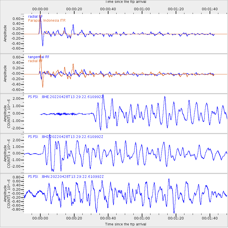
Signal To Noise
| Channel | StoN | STA | LTA |
| PS:PSI: :BHZ:20220428T13:29:22.610992Z | 10.794663 | 7.6925323E-7 | 7.126236E-8 |
| PS:PSI: :BHN:20220428T13:29:22.610992Z | 1.8001697 | 1.7132245E-7 | 9.517017E-8 |
| PS:PSI: :BHE:20220428T13:29:22.610992Z | 13.411999 | 6.4129057E-7 | 4.7814687E-8 |
| Arrivals |
| Ps | 7.6 SECOND |
| PpPs | 19 SECOND |
| PsPs/PpSs | 27 SECOND |


