You are here: Home > Network List > TX - Texas Seismological Network Stations List
> Station PLPT Palo Pinto > Earthquake Result Viewer
PLPT Palo Pinto - Earthquake Result Viewer
| Earthquake location: |
Central East Pacific Rise |
| Earthquake latitude/longitude: |
-4.5/-104.9 |
| Earthquake time(UTC): |
2022/04/29 (119) 08:33:28 GMT |
| Earthquake Depth: |
10 km |
| Earthquake Magnitude: |
5.6 mww |
| Earthquake Catalog/Contributor: |
NEIC PDE/us |
|
| Network: |
TX Texas Seismological Network |
| Station: |
PLPT Palo Pinto |
| Lat/Lon: |
32.81 N/98.32 W |
| Elevation: |
336 m |
|
| Distance: |
37.6 deg |
| Az: |
9.166 deg |
| Baz: |
190.871 deg |
| Ray Param: |
0.07603449 |
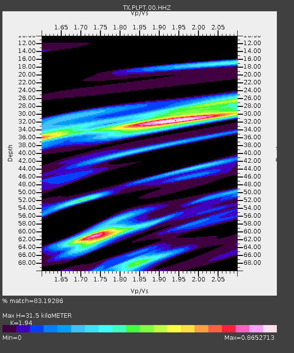
| Estimated Moho Depth: |
31.5 km |
| Estimated Crust Vp/Vs: |
1.94 |
| Assumed Crust Vp: |
6.426 km/s |
| Estimated Crust Vs: |
3.312 km/s |
| Estimated Crust Poisson's Ratio: |
0.32 |
|
| Radial Match: |
83.19286 % |
| Radial Bump: |
374 |
| Transverse Match: |
65.71356 % |
| Transverse Bump: |
400 |
| SOD ConfigId: |
27527651 |
| Insert Time: |
2022-05-13 08:55:52.664 +0000 |
| GWidth: |
2.5 |
| Max Bumps: |
400 |
| Tol: |
0.001 |
|

Signal To Noise
| Channel | StoN | STA | LTA |
| TX:PLPT:00:HHZ:20220429T08:40:12.755015Z | 2.2343254 | 2.4560296E-7 | 1.09922645E-7 |
| TX:PLPT:00:HH1:20220429T08:40:12.755015Z | 0.6849454 | 9.545402E-8 | 1.3936004E-7 |
| TX:PLPT:00:HH2:20220429T08:40:12.755015Z | 1.3514061 | 9.355027E-8 | 6.92244E-8 |
| Arrivals |
| Ps | 4.9 SECOND |
| PpPs | 13 SECOND |
| PsPs/PpSs | 18 SECOND |


