You are here: Home > Network List > AV - Alaska Volcano Observatory Stations List
> Station MAPS Pakushin Southeast, Makushin Volcano, Alaska > Earthquake Result Viewer
MAPS Pakushin Southeast, Makushin Volcano, Alaska - Earthquake Result Viewer

| Earthquake location: |
Volcano Islands, Japan Region |
| Earthquake latitude/longitude: |
23.6/142.7 |
| Earthquake time(UTC): |
2022/05/01 (121) 21:57:48 GMT |
| Earthquake Depth: |
51 km |
| Earthquake Magnitude: |
5.6 mww |
| Earthquake Catalog/Contributor: |
NEIC PDE/us |
|
| Network: |
AV Alaska Volcano Observatory |
| Station: |
MAPS Pakushin Southeast, Makushin Volcano, Alaska |
| Lat/Lon: |
53.81 N/166.94 W |
| Elevation: |
333 m |
|
| Distance: |
48.1 deg |
| Az: |
37.846 deg |
| Baz: |
251.583 deg |
| Ray Param: |
0.06946734 |
| Estimated Moho Depth: |
57.5 km |
| Estimated Crust Vp/Vs: |
1.91 |
| Assumed Crust Vp: |
3.943 km/s |
| Estimated Crust Vs: |
2.059 km/s |
| Estimated Crust Poisson's Ratio: |
0.31 |
|
| Radial Match: |
98.81379 % |
| Radial Bump: |
154 |
| Transverse Match: |
98.84865 % |
| Transverse Bump: |
188 |
| SOD ConfigId: |
27527651 |
| Insert Time: |
2022-05-15 22:04:12.854 +0000 |
| GWidth: |
2.5 |
| Max Bumps: |
400 |
| Tol: |
0.001 |
|
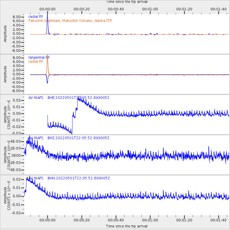
Signal To Noise
| Channel | StoN | STA | LTA |
| AV:MAPS: :BHZ:20220501T22:05:52.899005Z | 0.43864414 | 1.3987234E-9 | 3.1887428E-9 |
| AV:MAPS: :BHN:20220501T22:05:52.899005Z | 0.45841572 | 7.468473E-9 | 1.629192E-8 |
| AV:MAPS: :BHE:20220501T22:05:52.899005Z | 0.45151764 | 8.054889E-9 | 1.783959E-8 |
| Arrivals |
| Ps | 14 SECOND |
| PpPs | 42 SECOND |
| PsPs/PpSs | 55 SECOND |


