You are here: Home > Network List > G - GEOSCOPE Stations List
> Station ATD Arta Cave - Arta, Republic of Djibouti > Earthquake Result Viewer
ATD Arta Cave - Arta, Republic of Djibouti - Earthquake Result Viewer

| Earthquake location: |
Philippine Islands Region |
| Earthquake latitude/longitude: |
6.5/127.1 |
| Earthquake time(UTC): |
2022/05/05 (125) 08:21:17 GMT |
| Earthquake Depth: |
26 km |
| Earthquake Magnitude: |
5.9 mww |
| Earthquake Catalog/Contributor: |
NEIC PDE/us |
|
| Network: |
G GEOSCOPE |
| Station: |
ATD Arta Cave - Arta, Republic of Djibouti |
| Lat/Lon: |
11.53 N/42.85 E |
| Elevation: |
610 m |
|
| Distance: |
83.1 deg |
| Az: |
280.819 deg |
| Baz: |
84.761 deg |
| Ray Param: |
0.046366017 |
| Estimated Moho Depth: |
24.0 km |
| Estimated Crust Vp/Vs: |
1.76 |
| Assumed Crust Vp: |
6.375 km/s |
| Estimated Crust Vs: |
3.627 km/s |
| Estimated Crust Poisson's Ratio: |
0.26 |
|
| Radial Match: |
95.37022 % |
| Radial Bump: |
400 |
| Transverse Match: |
80.851944 % |
| Transverse Bump: |
400 |
| SOD ConfigId: |
27527651 |
| Insert Time: |
2022-05-19 08:31:37.969 +0000 |
| GWidth: |
2.5 |
| Max Bumps: |
400 |
| Tol: |
0.001 |
|
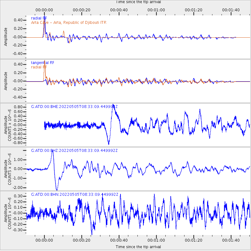
Signal To Noise
| Channel | StoN | STA | LTA |
| G:ATD:00:BHZ:20220505T08:33:09.449992Z | 16.962856 | 8.955239E-7 | 5.2793222E-8 |
| G:ATD:00:BHN:20220505T08:33:09.449992Z | 0.746523 | 5.1078022E-8 | 6.842122E-8 |
| G:ATD:00:BHE:20220505T08:33:09.449992Z | 4.5044928 | 3.4943537E-7 | 7.757486E-8 |
| Arrivals |
| Ps | 2.9 SECOND |
| PpPs | 10 SECOND |
| PsPs/PpSs | 13 SECOND |


