You are here: Home > Network List > MM - Myanmar National Seismic Network Stations List
> Station NGU Ngaung U, Myanmar > Earthquake Result Viewer
NGU Ngaung U, Myanmar - Earthquake Result Viewer
| Earthquake location: |
Philippine Islands Region |
| Earthquake latitude/longitude: |
6.5/127.1 |
| Earthquake time(UTC): |
2022/05/05 (125) 08:21:17 GMT |
| Earthquake Depth: |
26 km |
| Earthquake Magnitude: |
5.9 mww |
| Earthquake Catalog/Contributor: |
NEIC PDE/us |
|
| Network: |
MM Myanmar National Seismic Network |
| Station: |
NGU Ngaung U, Myanmar |
| Lat/Lon: |
21.21 N/94.92 E |
| Elevation: |
70 m |
|
| Distance: |
34.4 deg |
| Az: |
298.356 deg |
| Baz: |
110.428 deg |
| Ray Param: |
0.07771636 |
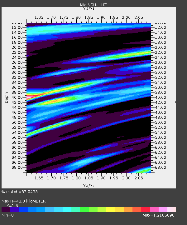
| Estimated Moho Depth: |
40.0 km |
| Estimated Crust Vp/Vs: |
1.60 |
| Assumed Crust Vp: |
6.036 km/s |
| Estimated Crust Vs: |
3.773 km/s |
| Estimated Crust Poisson's Ratio: |
0.18 |
|
| Radial Match: |
87.0433 % |
| Radial Bump: |
400 |
| Transverse Match: |
67.19871 % |
| Transverse Bump: |
400 |
| SOD ConfigId: |
27527651 |
| Insert Time: |
2022-05-19 08:34:24.571 +0000 |
| GWidth: |
2.5 |
| Max Bumps: |
400 |
| Tol: |
0.001 |
|

Signal To Noise
| Channel | StoN | STA | LTA |
| MM:NGU: :HHZ:20220505T08:27:31.75001Z | 9.090567 | 1.8944457E-6 | 2.0839687E-7 |
| MM:NGU: :HHN:20220505T08:27:31.75001Z | 2.294179 | 3.9116506E-7 | 1.7050328E-7 |
| MM:NGU: :HHE:20220505T08:27:31.75001Z | 3.1266696 | 6.6343904E-7 | 2.1218712E-7 |
| Arrivals |
| Ps | 4.3 SECOND |
| PpPs | 16 SECOND |
| PsPs/PpSs | 20 SECOND |


