You are here: Home > Network List > GS - US Geological Survey Networks Stations List
> Station OK031 S. Brethren Rd., Cushing, OK, USA > Earthquake Result Viewer
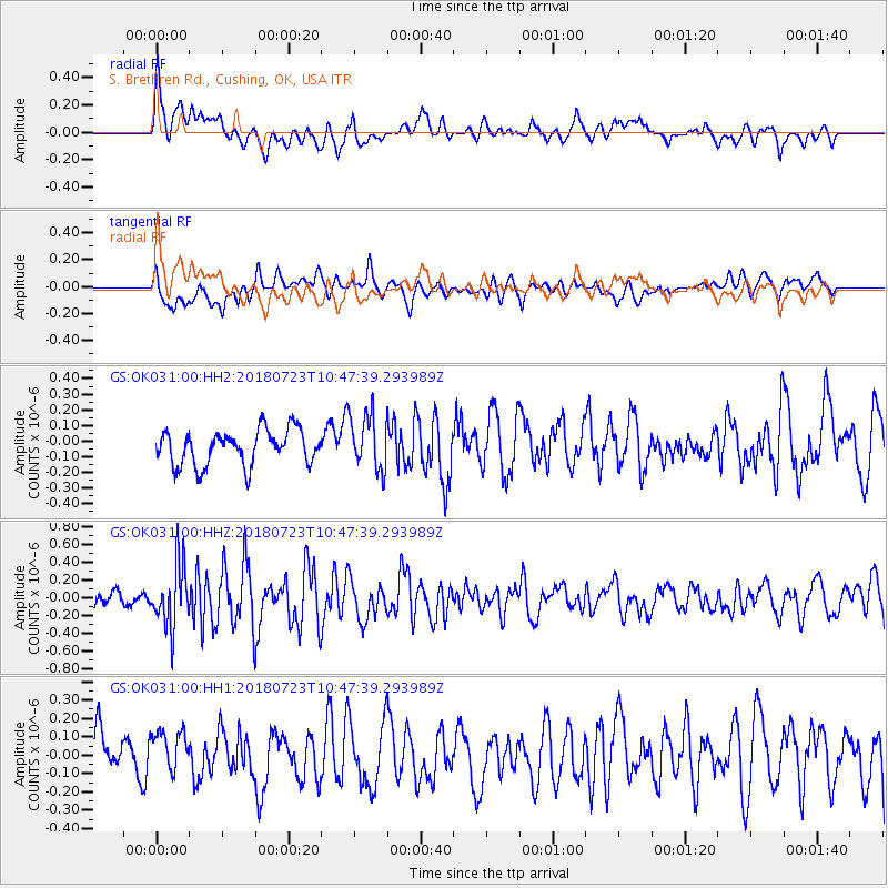
OK031 S. Brethren Rd., Cushing, OK, USA - Earthquake Result Viewer
*The percent match for this event was below the threshold and hence no stack was calculated.
| Earthquake location: |
Central Mid-Atlantic Ridge |
| Earthquake latitude/longitude: |
-0.3/-19.2 |
| Earthquake time(UTC): |
2018/07/23 (204) 10:36:00 GMT |
| Earthquake Depth: |
10 km |
| Earthquake Magnitude: |
5.9 Mww |
| Earthquake Catalog/Contributor: |
NEIC PDE/us |
|
| Network: |
GS US Geological Survey Networks |
| Station: |
OK031 S. Brethren Rd., Cushing, OK, USA |
| Lat/Lon: |
35.95 N/96.84 W |
| Elevation: |
290 m |
|
| Distance: |
80.2 deg |
| Az: |
306.463 deg |
| Baz: |
97.604 deg |
| Ray Param: |
$rayparam |
*The percent match for this event was below the threshold and hence was not used in the summary stack. |
|
| Radial Match: |
71.027695 % |
| Radial Bump: |
400 |
| Transverse Match: |
49.900955 % |
| Transverse Bump: |
400 |
| SOD ConfigId: |
2778632 |
| Insert Time: |
2018-08-06 10:38:14.822 +0000 |
| GWidth: |
2.5 |
| Max Bumps: |
400 |
| Tol: |
0.001 |
|
Signal To Noise
| Channel | StoN | STA | LTA |
| GS:OK031:00:HHZ:20180723T10:47:39.293989Z | 4.420799 | 3.5072233E-7 | 7.9334605E-8 |
| GS:OK031:00:HH1:20180723T10:47:39.293989Z | 0.8884438 | 1.2766299E-7 | 1.436928E-7 |
| GS:OK031:00:HH2:20180723T10:47:39.293989Z | 1.5935223 | 1.7839871E-7 | 1.1195244E-7 |
| Arrivals |
| Ps | |
| PpPs | |
| PsPs/PpSs | |


