You are here: Home > Network List > AV - Alaska Volcano Observatory Stations List
> Station GAEA East, Gareloi Volcano, Alaska > Earthquake Result Viewer
GAEA East, Gareloi Volcano, Alaska - Earthquake Result Viewer
| Earthquake location: |
Mariana Islands |
| Earthquake latitude/longitude: |
18.8/145.5 |
| Earthquake time(UTC): |
2022/05/07 (127) 16:58:12 GMT |
| Earthquake Depth: |
215 km |
| Earthquake Magnitude: |
5.6 mww |
| Earthquake Catalog/Contributor: |
NEIC PDE/us |
|
| Network: |
AV Alaska Volcano Observatory |
| Station: |
GAEA East, Gareloi Volcano, Alaska |
| Lat/Lon: |
51.78 N/178.75 W |
| Elevation: |
326 m |
|
| Distance: |
43.2 deg |
| Az: |
31.981 deg |
| Baz: |
233.88 deg |
| Ray Param: |
0.07184053 |
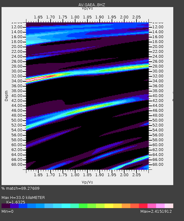
| Estimated Moho Depth: |
33.0 km |
| Estimated Crust Vp/Vs: |
1.63 |
| Assumed Crust Vp: |
6.048 km/s |
| Estimated Crust Vs: |
3.705 km/s |
| Estimated Crust Poisson's Ratio: |
0.20 |
|
| Radial Match: |
89.27689 % |
| Radial Bump: |
241 |
| Transverse Match: |
58.9023 % |
| Transverse Bump: |
400 |
| SOD ConfigId: |
27527651 |
| Insert Time: |
2022-05-21 17:03:18.903 +0000 |
| GWidth: |
2.5 |
| Max Bumps: |
400 |
| Tol: |
0.001 |
|

Signal To Noise
| Channel | StoN | STA | LTA |
| AV:GAEA: :BHZ:20220507T17:05:21.820009Z | 0.7273289 | 5.4894156E-7 | 7.547364E-7 |
| AV:GAEA: :BHN:20220507T17:05:21.820009Z | 0.63203084 | 9.631191E-7 | 1.5238483E-6 |
| AV:GAEA: :BHE:20220507T17:05:21.820009Z | 0.72724724 | 1.8917634E-6 | 2.601266E-6 |
| Arrivals |
| Ps | 3.7 SECOND |
| PpPs | 14 SECOND |
| PsPs/PpSs | 17 SECOND |


