You are here: Home > Network List > AK - Alaska Regional Network Stations List
> Station F20K Avaraart Lake, AK, USA > Earthquake Result Viewer
F20K Avaraart Lake, AK, USA - Earthquake Result Viewer
| Earthquake location: |
Halmahera, Indonesia |
| Earthquake latitude/longitude: |
1.8/127.2 |
| Earthquake time(UTC): |
2022/05/08 (128) 21:51:41 GMT |
| Earthquake Depth: |
56 km |
| Earthquake Magnitude: |
5.5 mww |
| Earthquake Catalog/Contributor: |
NEIC PDE/us |
|
| Network: |
AK Alaska Regional Network |
| Station: |
F20K Avaraart Lake, AK, USA |
| Lat/Lon: |
67.05 N/155.73 W |
| Elevation: |
136 m |
|
| Distance: |
83.4 deg |
| Az: |
22.635 deg |
| Baz: |
258.78 deg |
| Ray Param: |
0.046140436 |
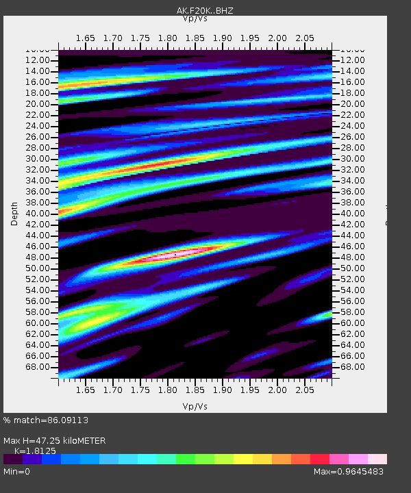
| Estimated Moho Depth: |
47.25 km |
| Estimated Crust Vp/Vs: |
1.81 |
| Assumed Crust Vp: |
6.522 km/s |
| Estimated Crust Vs: |
3.598 km/s |
| Estimated Crust Poisson's Ratio: |
0.28 |
|
| Radial Match: |
86.09113 % |
| Radial Bump: |
400 |
| Transverse Match: |
80.27055 % |
| Transverse Bump: |
400 |
| SOD ConfigId: |
27527651 |
| Insert Time: |
2022-05-22 21:54:46.763 +0000 |
| GWidth: |
2.5 |
| Max Bumps: |
400 |
| Tol: |
0.001 |
|

Signal To Noise
| Channel | StoN | STA | LTA |
| AK:F20K: :BHZ:20220508T22:03:31.160011Z | 18.779465 | 1.2090235E-6 | 6.438008E-8 |
| AK:F20K: :BHN:20220508T22:03:31.160011Z | 3.7904084 | 2.3201079E-7 | 6.1209974E-8 |
| AK:F20K: :BHE:20220508T22:03:31.160011Z | 8.875036 | 4.989351E-7 | 5.621781E-8 |
| Arrivals |
| Ps | 6.0 SECOND |
| PpPs | 20 SECOND |
| PsPs/PpSs | 26 SECOND |


