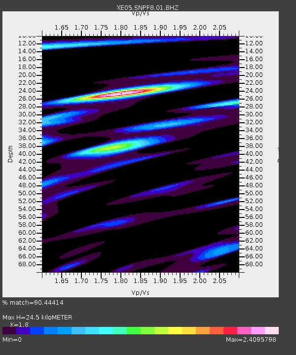
SNPF8 SNPF8 - Earthquake Result Viewer

Earthquake location: New Britain Region, P.N.G.
Earthquake latitude/longitude: -5.9/151.0
Earthquake time(UTC): 2006/10/17 (290) 01:25:12 GMT
Earthquake Depth: 32 km
Earthquake Magnitude: 6.4 MB, 6.9 MS, 6.7 MW, 6.6 MW
Earthquake Catalog/Contributor: WHDF/NEIC
Network: XE Sierra Nevada EarthScope Project- EarthScope Flex Array
Station: SNPF8 SNPF8
Lat/Lon: 40.01 N/120.64 W
Elevation: 2148 m
Distance: 92.5 deg
Az: 50.216 deg
Baz: 264.473 deg
Ray Param: 0.041436676
Estimated Moho Depth: 24.5 km
Estimated Crust Vp/Vs: 1.80
Assumed Crust Vp: 6.566 km/s
Estimated Crust Vs: 3.648 km/s
Estimated Crust Poisson's Ratio: 0.28
Radial Match: 90.44414 %
Radial Bump: 400
Transverse Match: 87.56986 %
Transverse Bump: 400
SOD ConfigId: 268666
Insert Time: 2010-03-09 19:26:53.618 +0000
GWidth: 2.5
Max Bumps: 400
Tol: 0.001

Signal To Noise

ChannelStoNSTALTA
XE:SNPF8:01:BHZ:20061017T01:37:48.74001Z18.884582.2851866E-61.2100807E-7
XE:SNPF8:01:BHN:20061017T01:37:48.74001Z2.1105523.0891778E-71.4636822E-7
XE:SNPF8:01:BHE:20061017T01:37:48.74001Z3.19269755.833683E-71.8271956E-7
Arrivals
Ps3.0 SECOND
PpPs10 SECOND
PsPs/PpSs13 SECOND