You are here: Home > Network List > XE05 - Sierra Nevada EarthScope Project- EarthScope Flex Array Stations List
> Station SNPF8 SNPF8 > Earthquake Result Viewer
SNPF8 SNPF8 - Earthquake Result Viewer
| Earthquake location: |
Near Coast Of Guatemala |
| Earthquake latitude/longitude: |
14.0/-91.2 |
| Earthquake time(UTC): |
2006/12/03 (337) 20:52:15 GMT |
| Earthquake Depth: |
61 km |
| Earthquake Magnitude: |
5.8 MB, 5.9 MW, 5.9 MW |
| Earthquake Catalog/Contributor: |
WHDF/NEIC |
|
| Network: |
XE Sierra Nevada EarthScope Project- EarthScope Flex Array |
| Station: |
SNPF8 SNPF8 |
| Lat/Lon: |
40.01 N/120.64 W |
| Elevation: |
2148 m |
|
| Distance: |
36.6 deg |
| Az: |
320.686 deg |
| Baz: |
126.799 deg |
| Ray Param: |
0.076442905 |
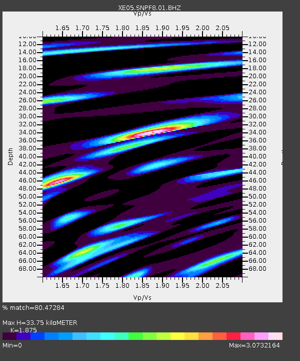
| Estimated Moho Depth: |
33.75 km |
| Estimated Crust Vp/Vs: |
1.88 |
| Assumed Crust Vp: |
6.566 km/s |
| Estimated Crust Vs: |
3.502 km/s |
| Estimated Crust Poisson's Ratio: |
0.30 |
|
| Radial Match: |
80.47284 % |
| Radial Bump: |
400 |
| Transverse Match: |
77.76137 % |
| Transverse Bump: |
400 |
| SOD ConfigId: |
268666 |
| Insert Time: |
2010-03-09 19:27:02.663 +0000 |
| GWidth: |
2.5 |
| Max Bumps: |
400 |
| Tol: |
0.001 |
|

Signal To Noise
| Channel | StoN | STA | LTA |
| XE:SNPF8:01:BHZ:20061203T20:58:45.48901Z | 5.2762856 | 6.104582E-7 | 1.1569848E-7 |
| XE:SNPF8:01:BHN:20061203T20:58:45.48901Z | 1.3674682 | 2.1717304E-7 | 1.5881396E-7 |
| XE:SNPF8:01:BHE:20061203T20:58:45.48901Z | 2.5116184 | 5.195273E-7 | 2.0684963E-7 |
| Arrivals |
| Ps | 4.8 SECOND |
| PpPs | 14 SECOND |
| PsPs/PpSs | 19 SECOND |


