You are here: Home > Network List > AK - Alaska Regional Network Stations List
> Station CAST Castle Rocks > Earthquake Result Viewer
CAST Castle Rocks - Earthquake Result Viewer
| Earthquake location: |
Taiwan Region |
| Earthquake latitude/longitude: |
24.0/122.5 |
| Earthquake time(UTC): |
2022/05/09 (129) 06:23:03 GMT |
| Earthquake Depth: |
27 km |
| Earthquake Magnitude: |
6.3 mww |
| Earthquake Catalog/Contributor: |
NEIC PDE/us |
|
| Network: |
AK Alaska Regional Network |
| Station: |
CAST Castle Rocks |
| Lat/Lon: |
63.42 N/152.08 W |
| Elevation: |
611 m |
|
| Distance: |
66.8 deg |
| Az: |
29.208 deg |
| Baz: |
277.306 deg |
| Ray Param: |
0.05735995 |
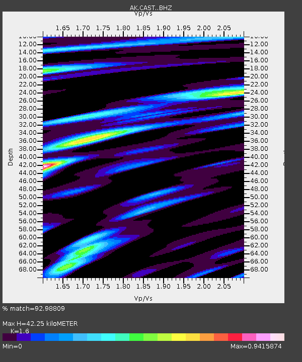
| Estimated Moho Depth: |
42.25 km |
| Estimated Crust Vp/Vs: |
1.60 |
| Assumed Crust Vp: |
6.566 km/s |
| Estimated Crust Vs: |
4.104 km/s |
| Estimated Crust Poisson's Ratio: |
0.18 |
|
| Radial Match: |
92.98809 % |
| Radial Bump: |
386 |
| Transverse Match: |
75.92007 % |
| Transverse Bump: |
400 |
| SOD ConfigId: |
27527651 |
| Insert Time: |
2022-05-23 06:25:20.059 +0000 |
| GWidth: |
2.5 |
| Max Bumps: |
400 |
| Tol: |
0.001 |
|

Signal To Noise
| Channel | StoN | STA | LTA |
| AK:CAST: :BHZ:20220509T06:33:21.02802Z | 7.3970475 | 7.061872E-7 | 9.546879E-8 |
| AK:CAST: :BHN:20220509T06:33:21.02802Z | 0.69062686 | 6.5424864E-8 | 9.4732584E-8 |
| AK:CAST: :BHE:20220509T06:33:21.02802Z | 4.38348 | 3.510304E-7 | 8.00803E-8 |
| Arrivals |
| Ps | 4.0 SECOND |
| PpPs | 16 SECOND |
| PsPs/PpSs | 20 SECOND |


