You are here: Home > Network List > AK - Alaska Regional Network Stations List
> Station CUT Chulitna, AK, USA > Earthquake Result Viewer
CUT Chulitna, AK, USA - Earthquake Result Viewer
| Earthquake location: |
Taiwan Region |
| Earthquake latitude/longitude: |
24.0/122.5 |
| Earthquake time(UTC): |
2022/05/09 (129) 06:23:03 GMT |
| Earthquake Depth: |
27 km |
| Earthquake Magnitude: |
6.3 mww |
| Earthquake Catalog/Contributor: |
NEIC PDE/us |
|
| Network: |
AK Alaska Regional Network |
| Station: |
CUT Chulitna, AK, USA |
| Lat/Lon: |
62.41 N/150.26 W |
| Elevation: |
574 m |
|
| Distance: |
67.7 deg |
| Az: |
30.169 deg |
| Baz: |
279.295 deg |
| Ray Param: |
0.056730375 |
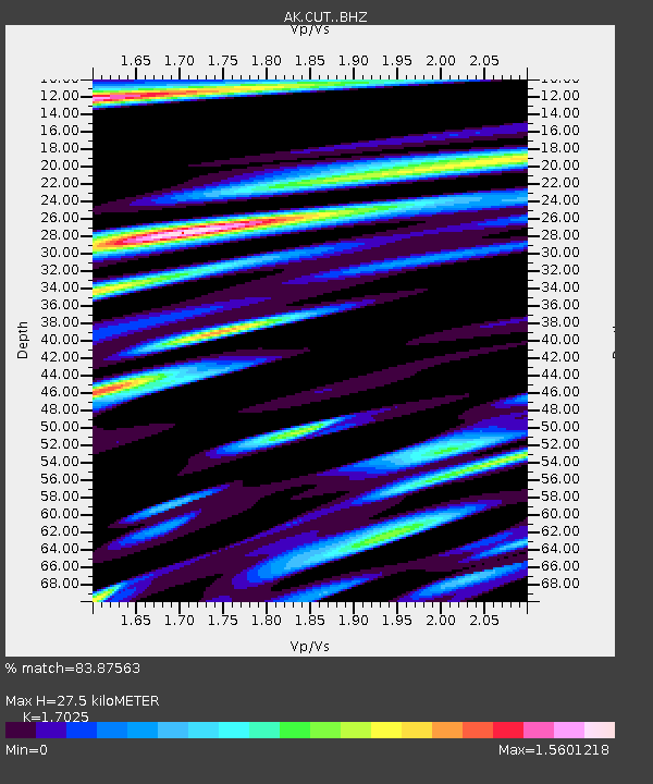
| Estimated Moho Depth: |
27.5 km |
| Estimated Crust Vp/Vs: |
1.70 |
| Assumed Crust Vp: |
6.438 km/s |
| Estimated Crust Vs: |
3.782 km/s |
| Estimated Crust Poisson's Ratio: |
0.24 |
|
| Radial Match: |
83.87563 % |
| Radial Bump: |
400 |
| Transverse Match: |
77.22788 % |
| Transverse Bump: |
400 |
| SOD ConfigId: |
27527651 |
| Insert Time: |
2022-05-23 06:25:27.816 +0000 |
| GWidth: |
2.5 |
| Max Bumps: |
400 |
| Tol: |
0.001 |
|
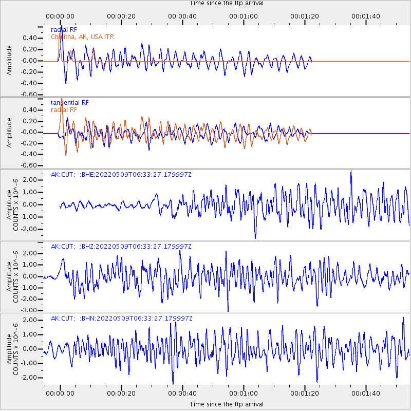
Signal To Noise
| Channel | StoN | STA | LTA |
| AK:CUT: :BHZ:20220509T06:33:27.179997Z | 5.7526355 | 8.652057E-7 | 1.5040162E-7 |
| AK:CUT: :BHN:20220509T06:33:27.179997Z | 1.7858737 | 4.5200886E-7 | 2.5310237E-7 |
| AK:CUT: :BHE:20220509T06:33:27.179997Z | 2.679957 | 4.6355638E-7 | 1.7297157E-7 |
| Arrivals |
| Ps | 3.1 SECOND |
| PpPs | 11 SECOND |
| PsPs/PpSs | 14 SECOND |


