You are here: Home > Network List > AK - Alaska Regional Network Stations List
> Station H16K Elim, AK, USA > Earthquake Result Viewer
H16K Elim, AK, USA - Earthquake Result Viewer
| Earthquake location: |
Taiwan Region |
| Earthquake latitude/longitude: |
24.0/122.5 |
| Earthquake time(UTC): |
2022/05/09 (129) 06:23:03 GMT |
| Earthquake Depth: |
27 km |
| Earthquake Magnitude: |
6.3 mww |
| Earthquake Catalog/Contributor: |
NEIC PDE/us |
|
| Network: |
AK Alaska Regional Network |
| Station: |
H16K Elim, AK, USA |
| Lat/Lon: |
64.64 N/162.24 W |
| Elevation: |
216 m |
|
| Distance: |
62.3 deg |
| Az: |
28.075 deg |
| Baz: |
267.693 deg |
| Ray Param: |
0.06031112 |
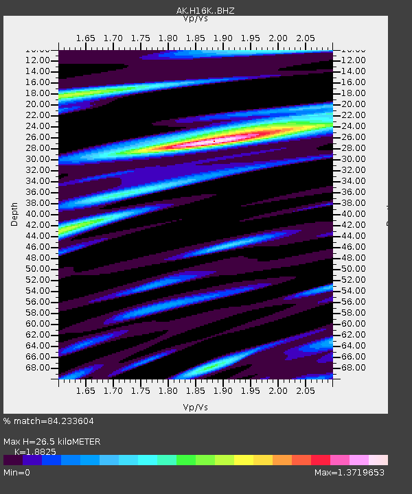
| Estimated Moho Depth: |
26.5 km |
| Estimated Crust Vp/Vs: |
1.88 |
| Assumed Crust Vp: |
6.276 km/s |
| Estimated Crust Vs: |
3.334 km/s |
| Estimated Crust Poisson's Ratio: |
0.30 |
|
| Radial Match: |
84.233604 % |
| Radial Bump: |
400 |
| Transverse Match: |
58.591877 % |
| Transverse Bump: |
400 |
| SOD ConfigId: |
27527651 |
| Insert Time: |
2022-05-23 06:26:18.644 +0000 |
| GWidth: |
2.5 |
| Max Bumps: |
400 |
| Tol: |
0.001 |
|

Signal To Noise
| Channel | StoN | STA | LTA |
| AK:H16K: :BHZ:20220509T06:32:51.59998Z | 4.1745887 | 5.682302E-7 | 1.3611645E-7 |
| AK:H16K: :BHN:20220509T06:32:51.59998Z | 1.1004659 | 1.7755981E-7 | 1.6134966E-7 |
| AK:H16K: :BHE:20220509T06:32:51.59998Z | 1.7007208 | 2.572822E-7 | 1.5127834E-7 |
| Arrivals |
| Ps | 3.9 SECOND |
| PpPs | 12 SECOND |
| PsPs/PpSs | 16 SECOND |


