You are here: Home > Network List > AV - Alaska Volcano Observatory Stations List
> Station N20K Mount Spurr, AK, USA > Earthquake Result Viewer
N20K Mount Spurr, AK, USA - Earthquake Result Viewer
| Earthquake location: |
Taiwan Region |
| Earthquake latitude/longitude: |
24.0/122.5 |
| Earthquake time(UTC): |
2022/05/09 (129) 06:23:03 GMT |
| Earthquake Depth: |
27 km |
| Earthquake Magnitude: |
6.3 mww |
| Earthquake Catalog/Contributor: |
NEIC PDE/us |
|
| Network: |
AV Alaska Volcano Observatory |
| Station: |
N20K Mount Spurr, AK, USA |
| Lat/Lon: |
61.20 N/152.21 W |
| Elevation: |
991 m |
|
| Distance: |
67.0 deg |
| Az: |
31.617 deg |
| Baz: |
278.139 deg |
| Ray Param: |
0.05719757 |
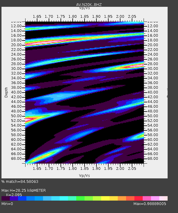
| Estimated Moho Depth: |
28.25 km |
| Estimated Crust Vp/Vs: |
2.10 |
| Assumed Crust Vp: |
6.566 km/s |
| Estimated Crust Vs: |
3.134 km/s |
| Estimated Crust Poisson's Ratio: |
0.35 |
|
| Radial Match: |
84.58063 % |
| Radial Bump: |
400 |
| Transverse Match: |
79.05762 % |
| Transverse Bump: |
400 |
| SOD ConfigId: |
27527651 |
| Insert Time: |
2022-05-23 06:31:31.512 +0000 |
| GWidth: |
2.5 |
| Max Bumps: |
400 |
| Tol: |
0.001 |
|

Signal To Noise
| Channel | StoN | STA | LTA |
| AV:N20K: :BHZ:20220509T06:33:22.575017Z | 6.9067817 | 7.2459176E-7 | 1.04910185E-7 |
| AV:N20K: :BHN:20220509T06:33:22.575017Z | 1.4283994 | 1.7489467E-7 | 1.2244101E-7 |
| AV:N20K: :BHE:20220509T06:33:22.575017Z | 2.1600046 | 2.3382584E-7 | 1.0825247E-7 |
| Arrivals |
| Ps | 4.9 SECOND |
| PpPs | 13 SECOND |
| PsPs/PpSs | 18 SECOND |


