You are here: Home > Network List > OX - North-East Italy Seismic Network Stations List
> Station DRE Drenchia > Earthquake Result Viewer
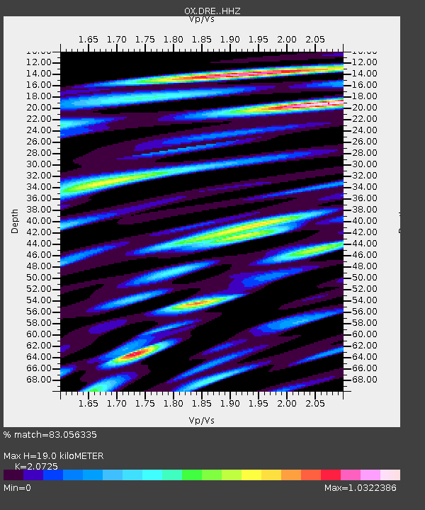
DRE Drenchia - Earthquake Result Viewer
| Earthquake location: |
Taiwan Region |
| Earthquake latitude/longitude: |
24.0/122.5 |
| Earthquake time(UTC): |
2022/05/09 (129) 06:23:03 GMT |
| Earthquake Depth: |
27 km |
| Earthquake Magnitude: |
6.3 mww |
| Earthquake Catalog/Contributor: |
NEIC PDE/us |
|
| Network: |
OX North-East Italy Seismic Network |
| Station: |
DRE Drenchia |
| Lat/Lon: |
46.17 N/13.65 E |
| Elevation: |
810 m |
|
| Distance: |
85.1 deg |
| Az: |
318.697 deg |
| Baz: |
60.288 deg |
| Ray Param: |
0.044992972 |
| Estimated Moho Depth: |
19.0 km |
| Estimated Crust Vp/Vs: |
2.07 |
| Assumed Crust Vp: |
6.35 km/s |
| Estimated Crust Vs: |
3.064 km/s |
| Estimated Crust Poisson's Ratio: |
0.35 |
|
| Radial Match: |
83.056335 % |
| Radial Bump: |
400 |
| Transverse Match: |
76.406136 % |
| Transverse Bump: |
400 |
| SOD ConfigId: |
27527651 |
| Insert Time: |
2022-05-23 06:42:36.178 +0000 |
| GWidth: |
2.5 |
| Max Bumps: |
400 |
| Tol: |
0.001 |
|

Signal To Noise
| Channel | StoN | STA | LTA |
| OX:DRE: :HHZ:20220509T06:35:05.080021Z | 9.419429 | 7.6863483E-7 | 8.1601E-8 |
| OX:DRE: :HHN:20220509T06:35:05.080021Z | 2.9018064 | 1.591172E-7 | 5.483385E-8 |
| OX:DRE: :HHE:20220509T06:35:05.080021Z | 3.3766649 | 2.3923386E-7 | 7.0849154E-8 |
| Arrivals |
| Ps | 3.3 SECOND |
| PpPs | 9.0 SECOND |
| PsPs/PpSs | 12 SECOND |


