You are here: Home > Network List > G - GEOSCOPE Stations List
> Station MPG Montagne des Peres, French Guyana > Earthquake Result Viewer
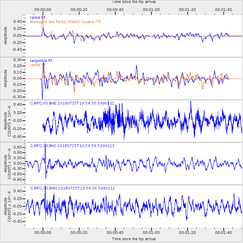
MPG Montagne des Peres, French Guyana - Earthquake Result Viewer
*The percent match for this event was below the threshold and hence no stack was calculated.
| Earthquake location: |
South Sandwich Islands Region |
| Earthquake latitude/longitude: |
-56.1/-27.7 |
| Earthquake time(UTC): |
2018/07/25 (206) 19:45:05 GMT |
| Earthquake Depth: |
125 km |
| Earthquake Magnitude: |
5.7 Mww |
| Earthquake Catalog/Contributor: |
NEIC PDE/us |
|
| Network: |
G GEOSCOPE |
| Station: |
MPG Montagne des Peres, French Guyana |
| Lat/Lon: |
5.11 N/52.64 W |
| Elevation: |
147 m |
|
| Distance: |
64.3 deg |
| Az: |
332.197 deg |
| Baz: |
164.773 deg |
| Ray Param: |
$rayparam |
*The percent match for this event was below the threshold and hence was not used in the summary stack. |
|
| Radial Match: |
50.272655 % |
| Radial Bump: |
400 |
| Transverse Match: |
60.278873 % |
| Transverse Bump: |
400 |
| SOD ConfigId: |
2778632 |
| Insert Time: |
2018-08-08 19:46:45.195 +0000 |
| GWidth: |
2.5 |
| Max Bumps: |
400 |
| Tol: |
0.001 |
|
Signal To Noise
| Channel | StoN | STA | LTA |
| G:MPG:00:BHZ:20180725T19:54:56.599011Z | 2.4490767 | 3.5114064E-7 | 1.4337675E-7 |
| G:MPG:00:BHN:20180725T19:54:56.599011Z | 1.6413027 | 1.6639707E-7 | 1.013811E-7 |
| G:MPG:00:BHE:20180725T19:54:56.599011Z | 0.99134254 | 1.2520474E-7 | 1.2629816E-7 |
| Arrivals |
| Ps | |
| PpPs | |
| PsPs/PpSs | |


