You are here: Home > Network List > AK - Alaska Regional Network Stations List
> Station H20K Anotleneega Mountain, AK, USA > Earthquake Result Viewer
H20K Anotleneega Mountain, AK, USA - Earthquake Result Viewer
| Earthquake location: |
Bismarck Sea |
| Earthquake latitude/longitude: |
-3.4/146.3 |
| Earthquake time(UTC): |
2022/05/09 (129) 22:33:06 GMT |
| Earthquake Depth: |
10 km |
| Earthquake Magnitude: |
6.3 mww |
| Earthquake Catalog/Contributor: |
NEIC PDE/us |
|
| Network: |
AK Alaska Regional Network |
| Station: |
H20K Anotleneega Mountain, AK, USA |
| Lat/Lon: |
65.49 N/154.88 W |
| Elevation: |
514 m |
|
| Distance: |
80.6 deg |
| Az: |
21.193 deg |
| Baz: |
239.906 deg |
| Ray Param: |
0.04814919 |
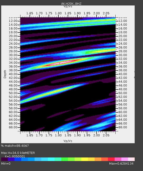
| Estimated Moho Depth: |
34.0 km |
| Estimated Crust Vp/Vs: |
1.81 |
| Assumed Crust Vp: |
6.566 km/s |
| Estimated Crust Vs: |
3.638 km/s |
| Estimated Crust Poisson's Ratio: |
0.28 |
|
| Radial Match: |
89.4067 % |
| Radial Bump: |
369 |
| Transverse Match: |
71.526665 % |
| Transverse Bump: |
400 |
| SOD ConfigId: |
27527651 |
| Insert Time: |
2022-05-23 22:35:19.017 +0000 |
| GWidth: |
2.5 |
| Max Bumps: |
400 |
| Tol: |
0.001 |
|

Signal To Noise
| Channel | StoN | STA | LTA |
| AK:H20K: :BHZ:20220509T22:44:48.179996Z | 4.006643 | 2.2834755E-7 | 5.6992242E-8 |
| AK:H20K: :BHN:20220509T22:44:48.179996Z | 0.75359297 | 4.6213188E-8 | 6.13238E-8 |
| AK:H20K: :BHE:20220509T22:44:48.179996Z | 0.9547571 | 5.4332077E-8 | 5.69067E-8 |
| Arrivals |
| Ps | 4.3 SECOND |
| PpPs | 14 SECOND |
| PsPs/PpSs | 18 SECOND |


