You are here: Home > Network List > AK - Alaska Regional Network Stations List
> Station M20K Styx River, AK, USA > Earthquake Result Viewer
M20K Styx River, AK, USA - Earthquake Result Viewer
| Earthquake location: |
Bismarck Sea |
| Earthquake latitude/longitude: |
-3.4/146.3 |
| Earthquake time(UTC): |
2022/05/09 (129) 22:33:06 GMT |
| Earthquake Depth: |
10 km |
| Earthquake Magnitude: |
6.3 mww |
| Earthquake Catalog/Contributor: |
NEIC PDE/us |
|
| Network: |
AK Alaska Regional Network |
| Station: |
M20K Styx River, AK, USA |
| Lat/Lon: |
61.88 N/153.13 W |
| Elevation: |
1107 m |
|
| Distance: |
79.6 deg |
| Az: |
24.795 deg |
| Baz: |
242.092 deg |
| Ray Param: |
0.048886232 |
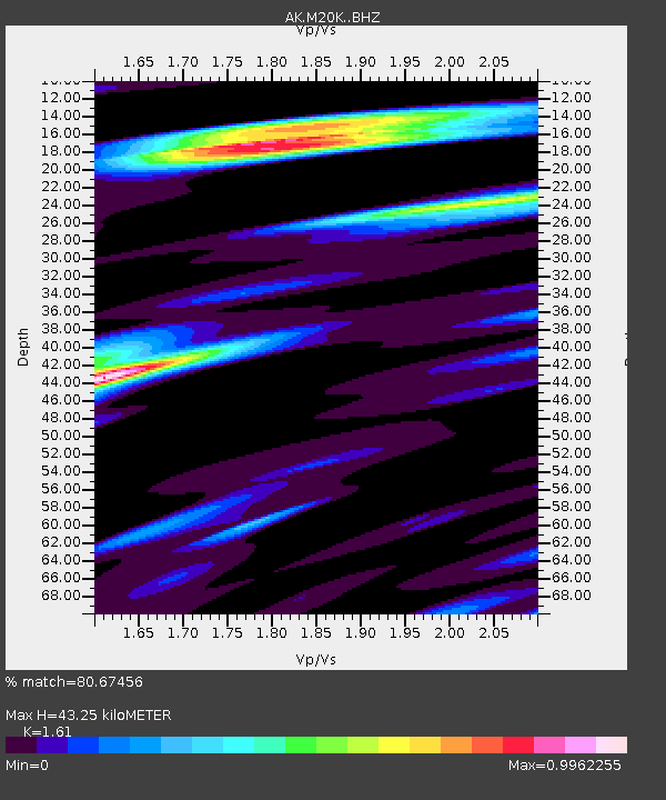
| Estimated Moho Depth: |
43.25 km |
| Estimated Crust Vp/Vs: |
1.61 |
| Assumed Crust Vp: |
6.566 km/s |
| Estimated Crust Vs: |
4.078 km/s |
| Estimated Crust Poisson's Ratio: |
0.19 |
|
| Radial Match: |
80.67456 % |
| Radial Bump: |
400 |
| Transverse Match: |
70.943665 % |
| Transverse Bump: |
400 |
| SOD ConfigId: |
27527651 |
| Insert Time: |
2022-05-23 22:35:56.345 +0000 |
| GWidth: |
2.5 |
| Max Bumps: |
400 |
| Tol: |
0.001 |
|

Signal To Noise
| Channel | StoN | STA | LTA |
| AK:M20K: :BHZ:20220509T22:44:42.400027Z | 2.6994276 | 2.945172E-7 | 1.09103574E-7 |
| AK:M20K: :BHN:20220509T22:44:42.400027Z | 1.9086287 | 1.3531545E-7 | 7.089668E-8 |
| AK:M20K: :BHE:20220509T22:44:42.400027Z | 1.6607283 | 1.4241819E-7 | 8.575646E-8 |
| Arrivals |
| Ps | 4.2 SECOND |
| PpPs | 17 SECOND |
| PsPs/PpSs | 21 SECOND |


