You are here: Home > Network List > TX - Texas Seismological Network Stations List
> Station PB29 Culberson North > Earthquake Result Viewer
PB29 Culberson North - Earthquake Result Viewer
| Earthquake location: |
Jujuy Province, Argentina |
| Earthquake latitude/longitude: |
-23.6/-66.9 |
| Earthquake time(UTC): |
2022/05/10 (130) 23:06:28 GMT |
| Earthquake Depth: |
235 km |
| Earthquake Magnitude: |
6.7 Mi |
| Earthquake Catalog/Contributor: |
NEIC PDE/at |
|
| Network: |
TX Texas Seismological Network |
| Station: |
PB29 Culberson North |
| Lat/Lon: |
31.75 N/104.51 W |
| Elevation: |
1242 m |
|
| Distance: |
65.8 deg |
| Az: |
325.234 deg |
| Baz: |
142.118 deg |
| Ray Param: |
0.057348914 |
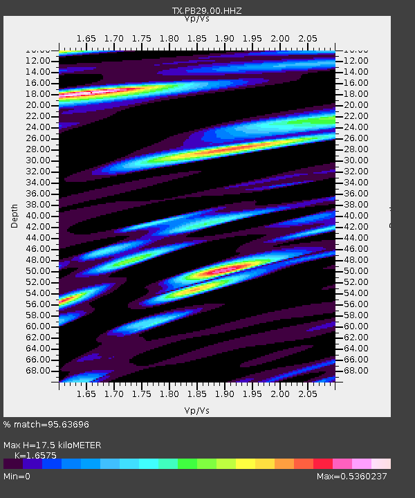
| Estimated Moho Depth: |
17.5 km |
| Estimated Crust Vp/Vs: |
1.66 |
| Assumed Crust Vp: |
6.361 km/s |
| Estimated Crust Vs: |
3.837 km/s |
| Estimated Crust Poisson's Ratio: |
0.21 |
|
| Radial Match: |
95.63696 % |
| Radial Bump: |
275 |
| Transverse Match: |
86.22605 % |
| Transverse Bump: |
400 |
| SOD ConfigId: |
27527651 |
| Insert Time: |
2022-05-24 23:22:44.377 +0000 |
| GWidth: |
2.5 |
| Max Bumps: |
400 |
| Tol: |
0.001 |
|

Signal To Noise
| Channel | StoN | STA | LTA |
| TX:PB29:00:HHZ:20220510T23:16:16.799988Z | 2.4653332 | 5.0500375E-7 | 2.0484201E-7 |
| TX:PB29:00:HH1:20220510T23:16:16.799988Z | 0.3931207 | 8.6930406E-8 | 2.2112903E-7 |
| TX:PB29:00:HH2:20220510T23:16:16.799988Z | 0.52077156 | 8.3794E-8 | 1.6090357E-7 |
| Arrivals |
| Ps | 1.9 SECOND |
| PpPs | 7.0 SECOND |
| PsPs/PpSs | 8.9 SECOND |


