You are here: Home > Network List > UW - Pacific Northwest Regional Seismic Network Stations List
> Station IZEE Izee, OR, USA > Earthquake Result Viewer
IZEE Izee, OR, USA - Earthquake Result Viewer
| Earthquake location: |
Jujuy Province, Argentina |
| Earthquake latitude/longitude: |
-23.6/-66.9 |
| Earthquake time(UTC): |
2022/05/10 (130) 23:06:28 GMT |
| Earthquake Depth: |
235 km |
| Earthquake Magnitude: |
6.7 Mi |
| Earthquake Catalog/Contributor: |
NEIC PDE/at |
|
| Network: |
UW Pacific Northwest Regional Seismic Network |
| Station: |
IZEE Izee, OR, USA |
| Lat/Lon: |
44.08 N/119.50 W |
| Elevation: |
1293 m |
|
| Distance: |
82.8 deg |
| Az: |
324.752 deg |
| Baz: |
132.726 deg |
| Ray Param: |
0.046062384 |
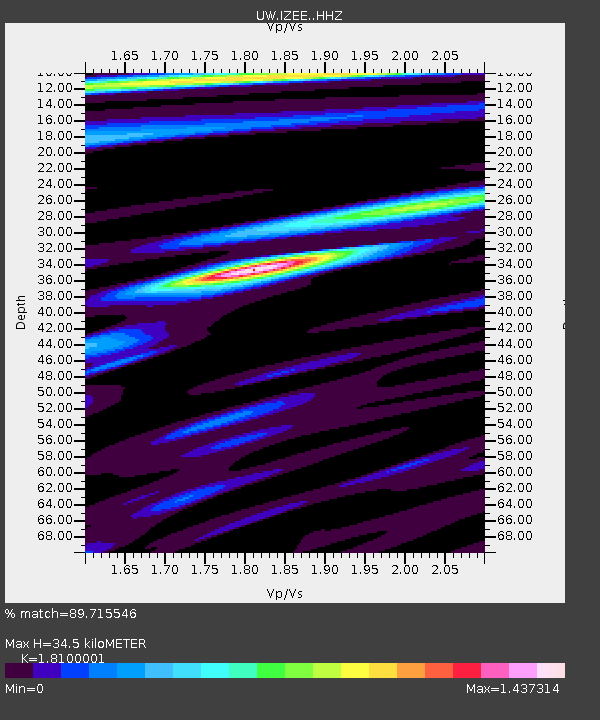
| Estimated Moho Depth: |
34.5 km |
| Estimated Crust Vp/Vs: |
1.81 |
| Assumed Crust Vp: |
6.571 km/s |
| Estimated Crust Vs: |
3.63 km/s |
| Estimated Crust Poisson's Ratio: |
0.28 |
|
| Radial Match: |
89.715546 % |
| Radial Bump: |
363 |
| Transverse Match: |
79.65314 % |
| Transverse Bump: |
400 |
| SOD ConfigId: |
27527651 |
| Insert Time: |
2022-05-24 23:24:26.855 +0000 |
| GWidth: |
2.5 |
| Max Bumps: |
400 |
| Tol: |
0.001 |
|

Signal To Noise
| Channel | StoN | STA | LTA |
| UW:IZEE: :HHZ:20220510T23:17:54.528015Z | 0.9907112 | 1.339412E-7 | 1.3519701E-7 |
| UW:IZEE: :HHN:20220510T23:17:54.528015Z | 1.0801779 | 1.0000403E-7 | 9.2581075E-8 |
| UW:IZEE: :HHE:20220510T23:17:54.528015Z | 1.3537086 | 1.980956E-7 | 1.4633548E-7 |
| Arrivals |
| Ps | 4.4 SECOND |
| PpPs | 14 SECOND |
| PsPs/PpSs | 19 SECOND |


