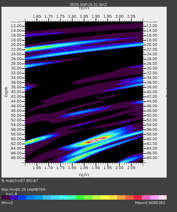
SNPG5 SNPG5 - Earthquake Result Viewer

Earthquake location: Solomon Islands
Earthquake latitude/longitude: -8.5/157.0
Earthquake time(UTC): 2007/04/01 (091) 20:39:56 GMT
Earthquake Depth: 10 km
Earthquake Magnitude: 6.8 MB, 7.9 MS, 8.1 MW, 7.7 ME
Earthquake Catalog/Contributor: WHDF/NEIC
Network: XE Sierra Nevada EarthScope Project- EarthScope Flex Array
Station: SNPG5 SNPG5
Lat/Lon: 39.72 N/121.53 W
Elevation: 652 m
Distance: 88.8 deg
Az: 49.715 deg
Baz: 258.076 deg
Ray Param: 0.042305686
Estimated Moho Depth: 60.25 km
Estimated Crust Vp/Vs: 1.90
Assumed Crust Vp: 6.597 km/s
Estimated Crust Vs: 3.472 km/s
Estimated Crust Poisson's Ratio: 0.31
Radial Match: 97.95167 %
Radial Bump: 317
Transverse Match: 92.11833 %
Transverse Bump: 400
SOD ConfigId: 268666
Insert Time: 2010-03-09 19:34:08.174 +0000
GWidth: 2.5
Max Bumps: 400
Tol: 0.001

Signal To Noise

ChannelStoNSTALTA
XE:SNPG5:01:BHZ:20070401T20:52:18.880Z13.9146311.755988E-61.2619725E-7
XE:SNPG5:01:BHN:20070401T20:52:18.880Z1.08879952.0372701E-71.8711158E-7
XE:SNPG5:01:BHE:20070401T20:52:18.880Z4.6828466.4101846E-71.368865E-7
Arrivals
Ps8.4 SECOND
PpPs26 SECOND
PsPs/PpSs34 SECOND