You are here: Home > Network List > AK - Alaska Regional Network Stations List
> Station PS10 TAPS Pump Station 10, AK, USA > Earthquake Result Viewer
PS10 TAPS Pump Station 10, AK, USA - Earthquake Result Viewer
| Earthquake location: |
Southeastern Uzbekistan |
| Earthquake latitude/longitude: |
38.1/66.9 |
| Earthquake time(UTC): |
2022/05/12 (132) 10:27:41 GMT |
| Earthquake Depth: |
10 km |
| Earthquake Magnitude: |
5.4 Mww |
| Earthquake Catalog/Contributor: |
NEIC PDE/us |
|
| Network: |
AK Alaska Regional Network |
| Station: |
PS10 TAPS Pump Station 10, AK, USA |
| Lat/Lon: |
63.42 N/145.77 W |
| Elevation: |
738 m |
|
| Distance: |
75.5 deg |
| Az: |
14.535 deg |
| Baz: |
333.89 deg |
| Ray Param: |
0.051634222 |
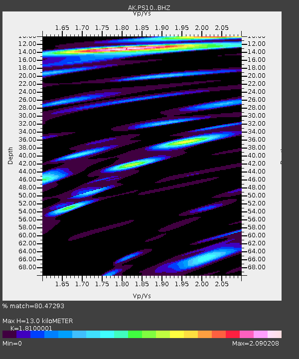
| Estimated Moho Depth: |
13.0 km |
| Estimated Crust Vp/Vs: |
1.81 |
| Assumed Crust Vp: |
6.566 km/s |
| Estimated Crust Vs: |
3.628 km/s |
| Estimated Crust Poisson's Ratio: |
0.28 |
|
| Radial Match: |
80.47293 % |
| Radial Bump: |
400 |
| Transverse Match: |
78.299706 % |
| Transverse Bump: |
400 |
| SOD ConfigId: |
27527651 |
| Insert Time: |
2022-05-26 10:32:49.236 +0000 |
| GWidth: |
2.5 |
| Max Bumps: |
400 |
| Tol: |
0.001 |
|

Signal To Noise
| Channel | StoN | STA | LTA |
| AK:PS10: :BHZ:20220512T10:38:54.967973Z | 7.362532 | 6.55764E-7 | 8.9067726E-8 |
| AK:PS10: :BHN:20220512T10:38:54.967973Z | 5.1309013 | 5.1597743E-7 | 1.0056272E-7 |
| AK:PS10: :BHE:20220512T10:38:54.967973Z | 6.9777203 | 4.879055E-7 | 6.992334E-8 |
| Arrivals |
| Ps | 1.7 SECOND |
| PpPs | 5.4 SECOND |
| PsPs/PpSs | 7.0 SECOND |


