You are here: Home > Network List > IU - Global Seismograph Network (GSN - IRIS/USGS) Stations List
> Station RSSD Black Hills, South Dakota, USA > Earthquake Result Viewer
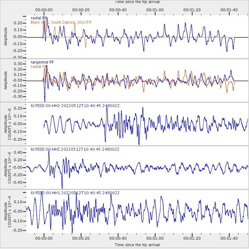
RSSD Black Hills, South Dakota, USA - Earthquake Result Viewer
*The percent match for this event was below the threshold and hence no stack was calculated.
| Earthquake location: |
Southeastern Uzbekistan |
| Earthquake latitude/longitude: |
38.1/66.9 |
| Earthquake time(UTC): |
2022/05/12 (132) 10:27:41 GMT |
| Earthquake Depth: |
10 km |
| Earthquake Magnitude: |
5.4 Mww |
| Earthquake Catalog/Contributor: |
NEIC PDE/us |
|
| Network: |
IU Global Seismograph Network (GSN - IRIS/USGS) |
| Station: |
RSSD Black Hills, South Dakota, USA |
| Lat/Lon: |
44.12 N/104.04 W |
| Elevation: |
2090 m |
|
| Distance: |
97.7 deg |
| Az: |
353.445 deg |
| Baz: |
7.183 deg |
| Ray Param: |
$rayparam |
*The percent match for this event was below the threshold and hence was not used in the summary stack. |
|
| Radial Match: |
48.516506 % |
| Radial Bump: |
400 |
| Transverse Match: |
56.074154 % |
| Transverse Bump: |
400 |
| SOD ConfigId: |
27527651 |
| Insert Time: |
2022-05-26 10:41:48.785 +0000 |
| GWidth: |
2.5 |
| Max Bumps: |
400 |
| Tol: |
0.001 |
|
Signal To Noise
| Channel | StoN | STA | LTA |
| IU:RSSD:00:HHZ:20220512T10:40:45.248002Z | 3.2137861 | 1.4456525E-7 | 4.4982844E-8 |
| IU:RSSD:00:HH1:20220512T10:40:45.248002Z | 1.606889 | 8.6739895E-8 | 5.3980013E-8 |
| IU:RSSD:00:HH2:20220512T10:40:45.248002Z | 1.4985636 | 9.177351E-8 | 6.124098E-8 |
| Arrivals |
| Ps | |
| PpPs | |
| PsPs/PpSs | |


