You are here: Home > Network List > PF - Volcanologic Network of Piton de Fournaise-OVPF Stations List
> Station GPS Grandes Pentes Sud > Earthquake Result Viewer
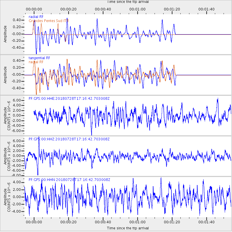
GPS Grandes Pentes Sud - Earthquake Result Viewer
*The percent match for this event was below the threshold and hence no stack was calculated.
| Earthquake location: |
Flores Sea |
| Earthquake latitude/longitude: |
-7.1/122.7 |
| Earthquake time(UTC): |
2018/07/28 (209) 17:07:23 GMT |
| Earthquake Depth: |
577 km |
| Earthquake Magnitude: |
6.0 Mww |
| Earthquake Catalog/Contributor: |
NEIC PDE/us |
|
| Network: |
PF Volcanologic Network of Piton de Fournaise-OVPF |
| Station: |
GPS Grandes Pentes Sud |
| Lat/Lon: |
21.27 S/55.76 E |
| Elevation: |
1004 m |
|
| Distance: |
66.0 deg |
| Az: |
249.971 deg |
| Baz: |
88.43 deg |
| Ray Param: |
$rayparam |
*The percent match for this event was below the threshold and hence was not used in the summary stack. |
|
| Radial Match: |
61.67396 % |
| Radial Bump: |
400 |
| Transverse Match: |
59.554684 % |
| Transverse Bump: |
400 |
| SOD ConfigId: |
2778632 |
| Insert Time: |
2018-08-11 17:10:06.871 +0000 |
| GWidth: |
2.5 |
| Max Bumps: |
400 |
| Tol: |
0.001 |
|
Signal To Noise
| Channel | StoN | STA | LTA |
| PF:GPS:00:HHZ:20180728T17:16:42.703008Z | 1.6227611 | 2.9259993E-6 | 1.8030992E-6 |
| PF:GPS:00:HHN:20180728T17:16:42.703008Z | 0.82587135 | 1.9166653E-6 | 2.3207795E-6 |
| PF:GPS:00:HHE:20180728T17:16:42.703008Z | 1.8459066 | 2.8730944E-6 | 1.556468E-6 |
| Arrivals |
| Ps | |
| PpPs | |
| PsPs/PpSs | |


