You are here: Home > Network List > IW - Intermountain West Stations List
> Station MOOW Moose Ponds, Wyoming, USA > Earthquake Result Viewer
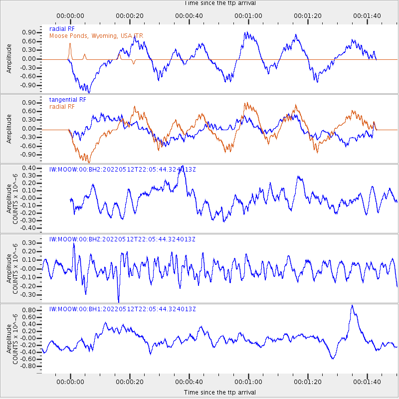
MOOW Moose Ponds, Wyoming, USA - Earthquake Result Viewer
*The percent match for this event was below the threshold and hence no stack was calculated.
| Earthquake location: |
Near Coast Of Peru |
| Earthquake latitude/longitude: |
-12.4/-76.9 |
| Earthquake time(UTC): |
2022/05/12 (132) 21:55:48 GMT |
| Earthquake Depth: |
56 km |
| Earthquake Magnitude: |
5.4 Mww |
| Earthquake Catalog/Contributor: |
NEIC PDE/us |
|
| Network: |
IW Intermountain West |
| Station: |
MOOW Moose Ponds, Wyoming, USA |
| Lat/Lon: |
43.75 N/110.74 W |
| Elevation: |
2128 m |
|
| Distance: |
63.8 deg |
| Az: |
333.26 deg |
| Baz: |
142.651 deg |
| Ray Param: |
$rayparam |
*The percent match for this event was below the threshold and hence was not used in the summary stack. |
|
| Radial Match: |
53.169716 % |
| Radial Bump: |
400 |
| Transverse Match: |
49.426785 % |
| Transverse Bump: |
400 |
| SOD ConfigId: |
27527651 |
| Insert Time: |
2022-05-26 22:08:31.551 +0000 |
| GWidth: |
2.5 |
| Max Bumps: |
400 |
| Tol: |
0.001 |
|
Signal To Noise
| Channel | StoN | STA | LTA |
| IW:MOOW:00:BHZ:20220512T22:05:44.324013Z | 2.0114312 | 1.2166737E-7 | 6.0487956E-8 |
| IW:MOOW:00:BH1:20220512T22:05:44.324013Z | 0.7229199 | 2.7306123E-7 | 3.777199E-7 |
| IW:MOOW:00:BH2:20220512T22:05:44.324013Z | 1.9400042 | 2.1661677E-7 | 1.1165789E-7 |
| Arrivals |
| Ps | |
| PpPs | |
| PsPs/PpSs | |


