You are here: Home > Network List > US - United States National Seismic Network Stations List
> Station MNTX Cornudas Mountains, Texas, USA > Earthquake Result Viewer
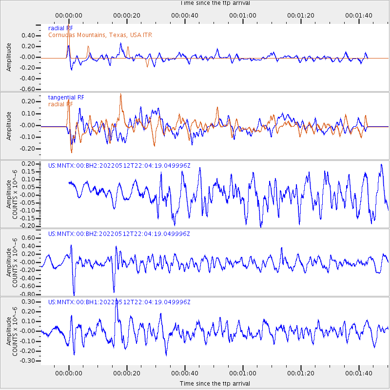
MNTX Cornudas Mountains, Texas, USA - Earthquake Result Viewer
*The percent match for this event was below the threshold and hence no stack was calculated.
| Earthquake location: |
Near Coast Of Peru |
| Earthquake latitude/longitude: |
-12.4/-76.9 |
| Earthquake time(UTC): |
2022/05/12 (132) 21:55:48 GMT |
| Earthquake Depth: |
56 km |
| Earthquake Magnitude: |
5.4 Mww |
| Earthquake Catalog/Contributor: |
NEIC PDE/us |
|
| Network: |
US United States National Seismic Network |
| Station: |
MNTX Cornudas Mountains, Texas, USA |
| Lat/Lon: |
31.70 N/105.38 W |
| Elevation: |
405 m |
|
| Distance: |
51.6 deg |
| Az: |
328.756 deg |
| Baz: |
143.518 deg |
| Ray Param: |
$rayparam |
*The percent match for this event was below the threshold and hence was not used in the summary stack. |
|
| Radial Match: |
66.887184 % |
| Radial Bump: |
400 |
| Transverse Match: |
60.673016 % |
| Transverse Bump: |
400 |
| SOD ConfigId: |
27527651 |
| Insert Time: |
2022-05-26 22:17:33.044 +0000 |
| GWidth: |
2.5 |
| Max Bumps: |
400 |
| Tol: |
0.001 |
|
Signal To Noise
| Channel | StoN | STA | LTA |
| US:MNTX:00:BHZ:20220512T22:04:19.049996Z | 3.3658702 | 2.9749415E-7 | 8.838551E-8 |
| US:MNTX:00:BH1:20220512T22:04:19.049996Z | 1.7861719 | 1.0630114E-7 | 5.9513386E-8 |
| US:MNTX:00:BH2:20220512T22:04:19.049996Z | 1.7359203 | 6.964988E-8 | 4.012274E-8 |
| Arrivals |
| Ps | |
| PpPs | |
| PsPs/PpSs | |


